|
search place name
|
||
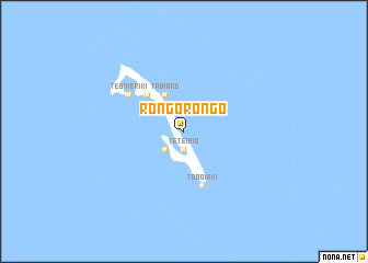
Rongorongo (Kiribati)Rongorongo is a town in Kiribati. An overview map of the region around Rongorongo is displayed below.
regional and 3d topo map of Rongorongo, Kiribati ::
Rongorongo airports ::
The nearest airport is TBF - Tabiteuea North, located 136.8 km west of Rongorongo.
Nearby towns ::
Nansaba (1.9km north) //
Teteirio (1.9km south) //
Nuka (1.9km south) //
Tabukiniberu (2.6km south west) //
Aoniman (4.1km north west) //
Tabiang (4.1km north west) //
Autokia (5.2km north west) //
Kariri (5.2km north west) //
Taboiaki (5.9km south) //
Tebikeriki (6.7km north west) //
[all distances 'as the bird flies' and approximate]  Places with similar names to Rongorongo, Kiribati ::
// Ringaringa (MG)
// Rangaranga (ID)
// Reungreung (ID)
// Ringring (PG)
// Rangaranga (ID)
// Rancairung (ID)
// Rang Rang (VN)
// Rằng Rảng (VN)
// Ruộng Ruồng (VN)
Disclaimer :: Information on this page comes without warranty of any kind |
||
|
Where is Rongorongo? Elevation and coordinates ::
Latitude (lat): 1°20'0"S Longitude (lon): 176°0'0"E
Elevation (approx.): 7m (map arrows pan, magnifying glasses zoom) |
||
|
Visiting Rongorongo? Hotel/Accommodation ::
Book a hotel in Rongorongo Travel Guide ::
Buy a travel guide for Kiribati rental cars ::
car rental offers GPS waypoint ::
download a GPX waypoint (PoI) of Rongorongo for your GPS receiver
|
||