|
search place name
|
||
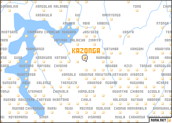
Kazonga (Malawi)Kazonga is a town in Malawi. An overview map of the region around Kazonga is displayed below.
regional and 3d topo map of Kazonga, Malawi ::
Kazonga airports ::
The nearest airport is LLW - Lilongwe Kamuzu Intl, located 52.4 km south of Kazonga.
Other airports nearby include VXC - Lichinga (157.1 km east), MFU - Mfuwe (203.8 km west), ZZU - Mzuzu (208.2 km north), Nearby towns ::
Jere (1.9km south) //
Omgolo (1.9km north) //
Chimpipo (1.8km west) //
Mtelemoga (2.6km south east) //
Kawenda (3.7km south) //
Kapoloza (3.7km south) //
Mwamuru (3.6km east) //
Chintamtumba (3.6km west) //
Chidatha (4.1km south east) //
Chilonje (4.1km south east) //
Chivala (4.1km north east) //
Zimpita (4.1km north east) //
Kambula (4.1km north west) //
Malaicha (4.1km north west) //
Kamsonga (4.1km north west) //
Nakutepa (5.2km south east) //
Mburuma (5.2km south east) //
Kamsale (5.2km south west) //
Katama (5.4km west) //
Kakonkwe (5.6km north) //
Jasi (5.6km north) //
Chiunjisa (5.4km east) //
Chisema (5.7km west) //
Kawenda (5.8km south) //
Seza (5.8km north) //
Madaba (5.7km east) //
Nbuyedziko (5.8km south) //
Katumba (5.7km east) //
Thengeza (6.6km south west) //
[all distances 'as the bird flies' and approximate]  Places with similar names to Kazonga, Malawi ::
Disclaimer :: Information on this page comes without warranty of any kind |
||
|
Where is Kazonga? Elevation and coordinates ::
Latitude (lat): 13°19'0"S Longitude (lon): 33°49'0"E
Elevation (approx.): 1219m (map arrows pan, magnifying glasses zoom) |
||
|
Visiting Kazonga? Hotel/Accommodation ::
Book a hotel in Kazonga Travel Guide ::
Buy a travel guide for Malawi rental cars ::
car rental offers GPS waypoint ::
download a GPX waypoint (PoI) of Kazonga for your GPS receiver
|
||