|
search place name
|
||
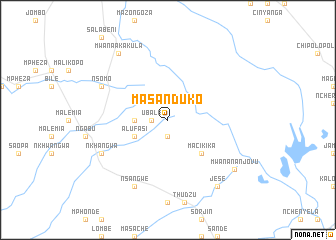
Masanduko (Malawi)Masanduko is a town in Malawi. An overview map of the region around Masanduko is displayed below.
regional and 3d topo map of Masanduko, Malawi ::
Masanduko airports ::
The nearest airport is BLZ - Blantyre Chileka Intl, located 85.3 km north of Masanduko.
Other airports nearby include TET - Tete Chingodzi (148.6 km west), UEL - Quelimane (253.9 km south east), Nearby towns ::
Ubale (1.8km west) //
Machilika (1.9km south) //
Balala (3.6km west) //
Alufasi (4.0km south west) //
Macikika (5.1km south east) //
Nsomo (8.0km north west) //
Bwemba (8.0km north west) //
Alufasi (8.0km south west) //
Nkhangwa (8.0km south west) //
Nsangwe (8.2km south west) //
Mwanaakakula (9.1km north west) //
Mwana Na Njovu (9.0km south east) //
Mbenje (9.0km south east) //
Jese (9.1km south east) //
[all distances 'as the bird flies' and approximate]  Places with similar names to Masanduko, Malawi ::
// Masintoc (PH)
// Mozóndiga (ES)
// Mzondeki (ZA)
// Masandiko (ZM)
// Massandougou (GN)
// Massandique (MZ)
// Massandique (MZ)
// Massandique (MZ)
// Masindugu (SL)
Disclaimer :: Information on this page comes without warranty of any kind |
||
|
Where is Masanduko? Elevation and coordinates ::
Latitude (lat): 16°27'0"S Longitude (lon): 34°59'0"E
Elevation (approx.): 56m (map arrows pan, magnifying glasses zoom) |
||
|
Visiting Masanduko? Hotel/Accommodation ::
Book a hotel in Masanduko Travel Guide ::
Buy a travel guide for Malawi rental cars ::
car rental offers GPS waypoint ::
download a GPX waypoint (PoI) of Masanduko for your GPS receiver
|
||