|
search place name
|
||
Azuretti (Cote d'Ivoire)Azuretti is a town in Cote d'Ivoire. An overview map of the region around Azuretti is displayed below.
regional and 3d topo map of Azuretti, Cote d'Ivoire ::
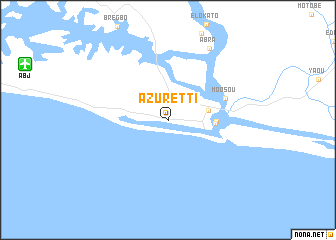
Azuretti airports ::
The nearest airport is ABJ - Abidjan Felix Houphouet Boigny Intl, located 17.1 km west of Azuretti.
Other airports nearby include ASK - Yamoussoukro (256.8 km north west), Nearby towns ::
Impérial (4.6km east) //
Grand-Bassam (5.3km east) //
France (5.4km east) //
Moosou (6.8km east) //
Abra (9.3km north east) //
[all distances 'as the bird flies' and approximate] 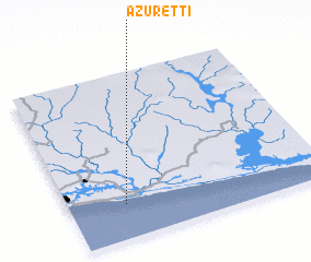 Places with similar names to Azuretti, Cote d'Ivoire ::
// Aouzert (MA)
// Aouzert (MA)
// Azrou Ouado (MA)
// Ausserroid (AT)
// Acereto (IT)
// Az Zārāt (TN)
// Acered (ES)
// Acereda (ES)
// Asarta (ES)
// Azrat (IR)
Disclaimer :: Information on this page comes without warranty of any kind |
||
|
Where is Azuretti? Elevation and coordinates ::
Latitude (lat): 5°12'21"N Longitude (lon): 3°46'58"W
Elevation (approx.): 1m (map arrows pan, magnifying glasses zoom) |
||
|
Visiting Azuretti? Hotel/Accommodation ::
Book a hotel in Azuretti Travel Guide ::
rental cars ::
car rental offers GPS waypoint ::
download a GPX waypoint (PoI) of Azuretti for your GPS receiver
|
||