|
search place name
|
||
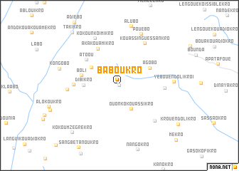
Baboukro (Cote d'Ivoire)Baboukro is a town in Cote d'Ivoire. An overview map of the region around Baboukro is displayed below.
regional and 3d topo map of Baboukro, Cote d'Ivoire ::
Baboukro airports ::
The nearest airport is BYK - Bouake, located 67.9 km north west of Baboukro.
Other airports nearby include ASK - Yamoussoukro (76.3 km south west), DJO - Daloa (196.1 km west), ABJ - Abidjan Felix Houphouet Boigny Intl (234.7 km south east), Nearby towns ::
Mamiénou (0.0km north) //
Ouonko-Kouassikro (4.1km south east) //
Konandiékro (5.2km north west) //
Agobo (5.4km north east) //
Dibikro (5.5km west) //
Boli (6.0km west) //
Atoou (6.5km north west) //
Aka-Kouamikro (6.6km north west) //
Abokoidiokro (7.1km west) //
Yeboué-Ndolikro II (7.1km east) //
Kouassi-Nguessankro (7.7km north east) //
Abokouassikro (7.8km south east) //
Grodiékro (8.1km west) //
Kokoun-Koimikro (8.2km north west) //
Yeboué-Ndolikro I (8.6km east) //
Pouébo (8.7km north east) //
Kokoum-Zégrékro (10.4km south west) //
Takikro (11.1km north west) //
[all distances 'as the bird flies' and approximate]  Places with similar names to Baboukro, Cote d'Ivoire ::
// Boubker (MA)
// Bābgūrī (IQ)
// Bībakir (IQ)
// Babia Góra (PL)
// Babia Góra (PL)
// Bubaqra (MT)
// Bāb Gorūh (IR)
// Bobokoré (TD)
// Bābūgarh (IN)
// Bābūgarh (IN)
Disclaimer :: Information on this page comes without warranty of any kind |
||
|
Where is Baboukro? Elevation and coordinates ::
Latitude (lat): 7°13'0"N Longitude (lon): 4°45'0"W
Elevation (approx.): 225m (map arrows pan, magnifying glasses zoom) |
||
|
Visiting Baboukro? Hotel/Accommodation ::
Book a hotel in Baboukro Travel Guide ::
rental cars ::
car rental offers GPS waypoint ::
download a GPX waypoint (PoI) of Baboukro for your GPS receiver
|
||