|
search place name
|
||
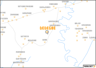
Dédegbé (Cote d'Ivoire)Dédegbé is a town in Cote d'Ivoire. An overview map of the region around Dédegbé is displayed below.
regional and 3d topo map of Dédegbé, Cote d'Ivoire ::
Dédegbé airports ::
The nearest airport is DJO - Daloa, located 34.1 km east of Dédegbé.
Other airports nearby include MJC - Man (110.1 km north west), ASK - Yamoussoukro (156.7 km east), SPY - San Pedro (216.8 km south), BYK - Bouake (219.4 km north east), Nearby towns ::
Débo (3.4km south west) //
Dairougbé II (3.7km north east) //
Dairougbé I (4.6km north east) //
Bédiégbe (7.1km south west) //
Zoukpangbeu (9.0km north) //
Daoungbé (10.9km north west) //
[all distances 'as the bird flies' and approximate]  Places with similar names to Dédegbé, Cote d'Ivoire ::
// Datu Guibu (PH)
// Dīda Guba (ET)
// Dīde Guba (ET)
// Tetegbu (GH)
// Totogaibi (PG)
// Ðệ Dức (1) (VN)
// Dadigba (CF)
// Titigbé (TG)
// Didi Gubi (GE)
Disclaimer :: Information on this page comes without warranty of any kind |
||
|
Where is Dédegbé? Elevation and coordinates ::
Latitude (lat): 6°42'16"N Longitude (lon): 6°46'8"W
Elevation (approx.): 225m (map arrows pan, magnifying glasses zoom) |
||
|
Visiting Dédegbé? Hotel/Accommodation ::
Book a hotel in Dédegbé Travel Guide ::
rental cars ::
car rental offers GPS waypoint ::
download a GPX waypoint (PoI) of Dédegbé for your GPS receiver
|
||