|
search place name
|
||
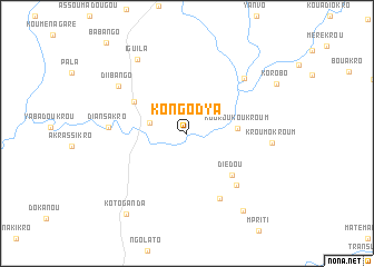
Kongodya (Cote d'Ivoire)Kongodya is a town in Cote d'Ivoire. An overview map of the region around Kongodya is displayed below.
regional and 3d topo map of Kongodya, Cote d'Ivoire ::
Kongodya airports ::
The nearest airport is NYI - Sunyani, located 99.5 km east of Kongodya.
Other airports nearby include BYK - Bouake (209.2 km west), Nearby towns ::
Bouroukrou (3.8km west) //
Kouroukoukroum (5.1km east) //
Diédou (6.1km south east) //
Assafo (6.2km north west) //
Pambasso (7.1km south east) //
Amorofikroum (7.3km south east) //
Diansakro (7.8km west) //
Abokouma (7.9km north east) //
Diibango (8.3km north west) //
Kroumokroum (8.6km east) //
Iguila (8.9km north west) //
Kankassua (9.5km south east) //
Koto-Ganda (10.1km south west) //
[all distances 'as the bird flies' and approximate]  Places with similar names to Kongodya, Cote d'Ivoire ::
// Goniketiya (LK)
// Kanuketiya (LK)
// Kanuketiya (LK)
// Kanuketiya (LK)
// Konketiya (LK)
// Cang Tây (4) (VN)
// Kaingdawye (MM)
Disclaimer :: Information on this page comes without warranty of any kind |
||
|
Where is Kongodya? Elevation and coordinates ::
Latitude (lat): 7°39'40"N Longitude (lon): 3°10'45"W
Elevation (approx.): 207m (map arrows pan, magnifying glasses zoom) |
||
|
Visiting Kongodya? Hotel/Accommodation ::
Book a hotel in Kongodya Travel Guide ::
rental cars ::
car rental offers GPS waypoint ::
download a GPX waypoint (PoI) of Kongodya for your GPS receiver
|
||