|
search place name
|
||
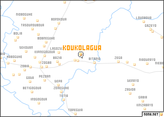
Koukolagua (Cote d'Ivoire)Koukolagua is a town in Cote d'Ivoire. An overview map of the region around Koukolagua is displayed below.
regional and 3d topo map of Koukolagua, Cote d'Ivoire ::
Koukolagua airports ::
The nearest airport is DJO - Daloa, located 32.4 km north of Koukolagua.
Other airports nearby include ASK - Yamoussoukro (133.1 km east), MJC - Man (147.3 km north west), SPY - San Pedro (194.8 km south), BYK - Bouake (208.8 km north east), Nearby towns ::
Béséréguhé (1.1km south west) //
Borotapia (1.7km west) //
Bitapia (3.0km east) //
Blanoguhé (5.3km west) //
Lagozuzua (5.5km west) //
Bazia (5.7km west) //
Dépa (8.2km south west) //
Zogba (8.3km west) //
Zéga (8.3km east) //
Kiprégogoua (8.6km west) //
Bobréguhé (9.0km north west) //
Zéréguhé (9.0km south west) //
Ouandia (9.0km west) //
Korekipra (9.2km north west) //
Borokoua (9.6km north west) //
Pézoan (9.8km south west) //
[all distances 'as the bird flies' and approximate] 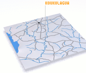 Places with similar names to Koukolagua, Cote d'Ivoire ::
Disclaimer :: Information on this page comes without warranty of any kind |
||
|
Where is Koukolagua? Elevation and coordinates ::
Latitude (lat): 6°30'3"N Longitude (lon): 6°30'1"W
Elevation (approx.): 190m (map arrows pan, magnifying glasses zoom) |
||
|
Visiting Koukolagua? Hotel/Accommodation ::
Book a hotel in Koukolagua Travel Guide ::
rental cars ::
car rental offers GPS waypoint ::
download a GPX waypoint (PoI) of Koukolagua for your GPS receiver
|
||