|
search place name
|
||
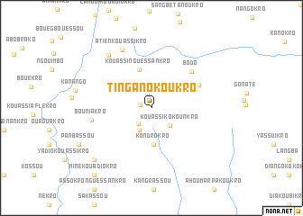
Ti-Ngan-Okoukro (Cote d'Ivoire)Ti-Ngan-Okoukro is a town in Cote d'Ivoire. An overview map of the region around Ti-Ngan-Okoukro is displayed below.
regional and 3d topo map of Ti-Ngan-Okoukro, Cote d'Ivoire ::
Ti-Ngan-Okoukro airports ::
The nearest airport is ASK - Yamoussoukro, located 60.0 km west of Ti-Ngan-Okoukro.
Other airports nearby include BYK - Bouake (83.2 km north), DJO - Daloa (182.7 km west), ABJ - Abidjan Felix Houphouet Boigny Intl (219.4 km south east), Nearby towns ::
Kongoué-Kouadiokro (1.4km west) //
Nglobo (1.8km north) //
Mangouakro (2.6km south west) //
Andokoy-Kokorékro (3.1km south west) //
Yalombi-Kouassikro (3.1km south west) //
Kouassi-Kokounkro (3.2km south east) //
Kondrokro (4.6km south) //
Kouassi-Nguessankro (5.0km north) //
Groyakro (6.5km north east) //
Bodo (6.6km north east) //
Bouniakro (7.5km west) //
Atien-Kouassikro (8.1km north west) //
Topayakro (8.4km north west) //
Konan Kékréko (9.5km south west) //
Miné Kouadiokro (10.9km south west) //
[all distances 'as the bird flies' and approximate]  Places with similar names to Ti-Ngan-Okoukro, Cote d'Ivoire ::
// Tungan Kogoro (NG)
Disclaimer :: Information on this page comes without warranty of any kind |
||
|
Where is Ti-Ngan-Okoukro? Elevation and coordinates ::
Latitude (lat): 7°1'28"N Longitude (lon): 4°50'10"W
Elevation (approx.): 204m (map arrows pan, magnifying glasses zoom) |
||
|
Visiting Ti-Ngan-Okoukro? Hotel/Accommodation ::
Book a hotel in Ti-Ngan-Okoukro Travel Guide ::
rental cars ::
car rental offers GPS waypoint ::
download a GPX waypoint (PoI) of Ti-Ngan-Okoukro for your GPS receiver
|
||