|
search place name
|
||
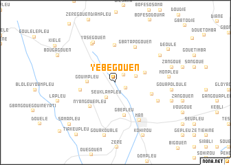
Yébegouen (Cote d'Ivoire)Yébegouen is a town in Cote d'Ivoire. An overview map of the region around Yébegouen is displayed below.
regional and 3d topo map of Yébegouen, Cote d'Ivoire ::
Yébegouen airports ::
The nearest airport is MJC - Man, located 20.9 km south of Yébegouen.
Other airports nearby include DJO - Daloa (143.1 km south east), Nearby towns ::
Bantégouen (1.9km north east) //
Gouétita (1.9km south east) //
Seuklampleu (2.8km south west) //
Gangouen (2.9km north west) //
Zogouale (3.4km east) //
Gouimpleu (4.5km west) //
Gouegouapleu (5.0km east) //
Gbépleu (5.5km south) //
Nyangouépleu (5.7km south west) //
Bangouale (5.8km west) //
Gouénégouen (6.0km north) //
Glongoen (6.1km east) //
Gbatapogouen (6.6km north east) //
Man (7.3km south east) //
Souénégouen (7.3km north west) //
Yaségouen (7.4km north west) //
Gbapleu (7.5km south east) //
Mengouen (8.4km north east) //
Monpleu (8.7km east) //
Gouakoualé (8.8km south) //
Kohirou (9.7km south east) //
Déoulé (10.0km north east) //
Samapleu (10.1km south west) //
Tiakeupleu (10.6km south west) //
[all distances 'as the bird flies' and approximate] 
Disclaimer :: Information on this page comes without warranty of any kind |
||
|
Where is Yébegouen? Elevation and coordinates ::
Latitude (lat): 7°27'39"N Longitude (lon): 7°34'56"W
Elevation (approx.): 407m (map arrows pan, magnifying glasses zoom) |
||
|
Visiting Yébegouen? Hotel/Accommodation ::
Book a hotel in Yébegouen Travel Guide ::
rental cars ::
car rental offers GPS waypoint ::
download a GPX waypoint (PoI) of Yébegouen for your GPS receiver
|
||