|
search place name
|
||
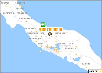
Santa Maria (Netherlands Antilles)Santa Maria is a town in Netherlands Antilles. An overview map of the region around Santa Maria is displayed below.
regional and 3d topo map of Santa Maria, Netherlands Antilles ::
Santa Maria airports ::
The nearest airport is CUR - Willemstad Hato, located 5.2 km north west of Santa Maria.
Other airports nearby include BON - Kralendijk Flamingo (72.4 km east), CZE - Coro Jose Leonardo Chirinos (115.2 km south west), AUA - Oranjestad Reina Beatrix Intl (123.9 km west), LSP - Paraguana Josefa Camejo (138.8 km west), Nearby towns ::
Weis (0.0km north) //
Suriname Dorp (0.0km north) //
Blomonte (0.0km north) //
Piedras Negras (0.8km south west) //
Rancho (1.8km east) //
Suffisant Dorp (1.8km east) //
Julianadorp (1.8km west) //
Fortuna Abou (2.6km north east) //
Groot Kwartier (2.6km south east) //
Emmastad (2.6km south east) //
De Hoop (2.6km south west) //
Juan Domingo (2.6km north west) //
Buena Vista (2.6km south west) //
Roosendaal (2.6km south west) //
Habai (3.1km south west) //
Welgelegen (3.6km south west) //
Brievengat (3.6km east) //
Valentijn (3.7km south) //
Marchena (3.7km south) //
Motet (3.7km south) //
Jan Doret (3.6km west) //
Domi (3.8km south) //
Kortijn (3.9km south) //
Mundo (4.1km south) //
Colon (4.1km south) //
Seritu (4.1km south east) //
Otrabanda (4.1km south west) //
Australie (4.1km south west) //
Gato (4.1km north west) //
[all distances 'as the bird flies' and approximate]  Places with similar names to Santa Maria, Netherlands Antilles ::
// Santa Maria (BR)
// Santa Maria (BR)
// Santa Maria (BR)
// Santa Maria (BR)
// Santa Maria (BR)
// Santa Maria (BR)
// Santa Maria (BR)
// Santa Maria (BR)
// Santa Maria (BR)
// Santa Maria (BR)
Disclaimer :: Information on this page comes without warranty of any kind |
||
|
Where is Santa Maria? Elevation and coordinates ::
Latitude (lat): 12°9'0"N Longitude (lon): 68°56'0"W
Elevation (approx.): 33m (map arrows pan, magnifying glasses zoom) |
||
|
Visiting Santa Maria? Hotel/Accommodation ::
Book a hotel in Santa Maria Travel Guide ::
rental cars ::
car rental offers GPS waypoint ::
download a GPX waypoint (PoI) of Santa Maria for your GPS receiver
|
||