|
search place name
|
||
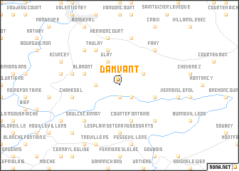
Damvant (Aargau, Switzerland)Damvant is a town in the Aargau region of Switzerland. An overview map of the region around Damvant is displayed below.
regional and 3d topo map of Damvant, Switzerland ::
Damvant airports ::
The nearest airport is MLH - Bale Mulhouse, located 53.6 km north east of Damvant.
Other airports nearby include BRN - Bern Belp (67.7 km south east), CMR - Colmar Houssen (89.5 km north), DLE - Dole Tavaux (117.4 km west), EPL - Epinal Mirecourt (123.3 km north west), Nearby towns ::
Dannemarie (1.9km north) //
Montjoie-le-Château (1.9km south) //
Vaufrey (2.2km south east) //
Villars-lès-Blamont (2.5km west) //
Grandfontaine (3.1km north east) //
Glay (3.9km north) //
Blamont (4.2km north west) //
Meslières (5.7km north) //
Montursin (4.2km south east) //
Courtefontaine (5.7km south) //
Thulay (6.1km north west) //
Les Plains-et-Grands-Essarts (7.4km south) //
Hérimoncourt (7.5km north) //
Abbévillers (7.5km north) //
Pierrefontaine-lès-Blamont (5.4km west) //
Chamesol (5.4km west) //
Fahy (6.7km north east) //
Roches-lès-Blamont (6.7km north west) //
Indevillers (6.7km south east) //
Soulce-Cernay (6.7km south west) //
Montandon (9.0km south west) //
[all distances 'as the bird flies' and approximate]  Places with similar names to Damvant, Switzerland ::
// Damāvand (IR)
// Tambafoundé (ML)
Disclaimer :: Information on this page comes without warranty of any kind |
||
|
Where is Damvant? Elevation and coordinates ::
Latitude (lat): 47°22'0"N Longitude (lon): 6°54'0"E
Elevation (approx.): 628m (map arrows pan, magnifying glasses zoom) |
||
|
Visiting Damvant? Hotel/Accommodation ::
Book a hotel in Damvant Travel Guide ::
Buy a travel guide for Switzerland rental cars ::
car rental offers GPS waypoint ::
download a GPX waypoint (PoI) of Damvant for your GPS receiver
|
||