|
search place name
|
||
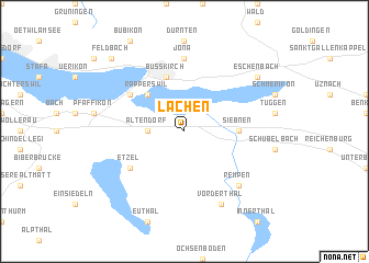
Lachen (Aargau, Switzerland)Lachen is a town in the Aargau region of Switzerland. An overview map of the region around Lachen is displayed below.
regional and 3d topo map of Lachen, Switzerland ::
nearby GPS traces from timatio ::
Lachen airports ::
The nearest airport is ZRH - Zurich, located 38.7 km north west of Lachen.
Other airports nearby include ACH - St Gallen Altenrhein (63.3 km north east), FDH - Friedrichshafen (73.7 km north east), ZQL - Donaueschingen Villingen (91.2 km north), SMV - Samedan (106.9 km south east), Nearby towns ::
Altendorf (2.5km west) //
Rapperswil (4.5km north west) //
Siebnen (3.8km east) //
Wangen (3.8km east) //
Busskirch (5.7km north) //
Etzel (5.3km south west) //
Hurden (5.3km north west) //
Rüti (7.4km north) //
Jona (7.4km north) //
Rempen (6.7km south east) //
Vorderthal (7.8km south) //
Eschenbach (7.5km north east) //
Feldbach (9.0km north west) //
[all distances 'as the bird flies' and approximate] 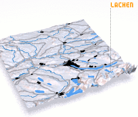 Places with similar names to Lachen, Switzerland ::
Disclaimer :: Information on this page comes without warranty of any kind |
||
|
Where is Lachen? Elevation and coordinates ::
Latitude (lat): 47°11'0"N Longitude (lon): 8°51'0"E
Elevation (approx.): 436m (map arrows pan, magnifying glasses zoom) |
||
|
Visiting Lachen? Hotel/Accommodation ::
Book a hotel in Lachen Travel Guide ::
Buy a travel guide for Switzerland rental cars ::
car rental offers GPS waypoint ::
download a GPX waypoint (PoI) of Lachen for your GPS receiver
|
||