|
search place name
|
||
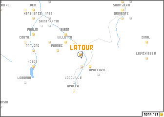
La Tour (Aargau, Switzerland)La Tour is a town in the Aargau region of Switzerland. An overview map of the region around La Tour is displayed below.
regional and 3d topo map of La Tour, Switzerland ::
La Tour airports ::
The nearest airport is SIR - Sion, located 18.9 km north west of La Tour.
Other airports nearby include BRN - Bern Belp (90.5 km north), QNJ - Annemasse (95.7 km west), TRN - Torino (100.6 km south), GVA - Geneva Cointrin (108.5 km west), Nearby towns ::
Pralovin (1.9km south) //
Evolène (1.9km north) //
Haudères (2.3km south east) //
Lannaz (3.9km north) //
Villetta (4.5km north west) //
Prafloric (4.5km south east) //
Vernec (4.3km north west) //
La Gouille (5.7km south) //
Eison (6.1km north west) //
La Monta (7.5km south) //
Arolla (7.5km south) //
Gravelon (6.3km north west) //
Saint-Martin (9.0km north west) //
La Crêta (9.0km north west) //
[all distances 'as the bird flies' and approximate] 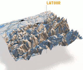 Places with similar names to La Tour, Switzerland ::
Disclaimer :: Information on this page comes without warranty of any kind |
||
|
Where is La Tour? Elevation and coordinates ::
Latitude (lat): 46°6'0"N Longitude (lon): 7°30'0"E
Elevation (approx.): 1416m (map arrows pan, magnifying glasses zoom) |
||
|
Visiting La Tour? Hotel/Accommodation ::
Book a hotel in La Tour Travel Guide ::
Buy a travel guide for Switzerland rental cars ::
car rental offers GPS waypoint ::
download a GPX waypoint (PoI) of La Tour for your GPS receiver
|
||