|
search place name
|
||
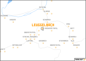
Leuggelbach (Aargau, Switzerland)Leuggelbach is a town in the Aargau region of Switzerland. An overview map of the region around Leuggelbach is displayed below.
regional and 3d topo map of Leuggelbach, Switzerland ::
Leuggelbach airports ::
The nearest airport is ZRH - Zurich, located 67.1 km north west of Leuggelbach.
Other airports nearby include ACH - St Gallen Altenrhein (69.4 km north east), SMV - Samedan (79.8 km south east), FDH - Friedrichshafen (85.8 km north east), LUG - Lugano (107.5 km south), Nearby towns ::
Nidfurn (1.9km north) //
Luchsingen (1.3km west) //
Schwanden (2.2km north east) //
Dornhaus (2.2km south west) //
Hätzingen (2.2km south west) //
Niedern Stafel (2.5km east) //
Sool (3.1km north east) //
Betschwanden (3.1km south west) //
Schwändi (3.9km north) //
Rüti (4.5km south west) //
Diesbach (5.6km south) //
Ober Staffel (4.2km south west) //
Stachelberg Bad (5.3km south west) //
Glarus (7.5km north) //
Linthal (6.7km south west) //
Ennenda (7.8km north) //
Braunwald (6.3km south west) //
Ober Stafel (8.3km south east) //
[all distances 'as the bird flies' and approximate] 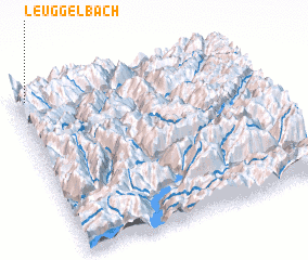 Places with similar names to Leuggelbach, Switzerland ::
// Lac La Biche (CA)
Disclaimer :: Information on this page comes without warranty of any kind |
||
|
Where is Leuggelbach? Elevation and coordinates ::
Latitude (lat): 46°58'0"N Longitude (lon): 9°3'0"E
Elevation (approx.): 808m (map arrows pan, magnifying glasses zoom) |
||
|
Visiting Leuggelbach? Hotel/Accommodation ::
Book a hotel in Leuggelbach Travel Guide ::
Buy a travel guide for Switzerland rental cars ::
car rental offers GPS waypoint ::
download a GPX waypoint (PoI) of Leuggelbach for your GPS receiver
|
||