|
search place name
|
||
Romanel (Aargau, Switzerland)Romanel is a town in the Aargau region of Switzerland. An overview map of the region around Romanel is displayed below.
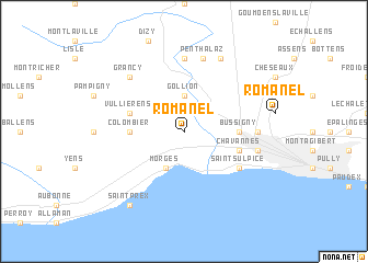
regional and 3d topo map of Romanel, Switzerland ::
nearby GPS traces from timatio ::
Romanel airports ::
The nearest airport is QNJ - Annemasse, located 44.1 km south west of Romanel.
Other airports nearby include GVA - Geneva Cointrin (46.8 km south west), SIR - Sion (72.3 km south east), NCY - Annecy Meythet (76.2 km south west), BRN - Bern Belp (85.2 km north east), Nearby towns ::
Gollion (3.7km north) //
Morges (3.9km south) //
Bussigny (3.8km east) //
Colombier (3.8km west) //
Chavannes (4.2km south east) //
Vullierens (4.2km north west) //
Saint-Sulpice (5.3km south east) //
Crissier (5.1km east) //
Cossonay (7.4km north) //
Renens (5.4km east) //
Prilly (5.4km east) //
Penthalaz (7.5km north) //
Grancy (6.7km north west) //
Daillens (7.8km north) //
Saint-Prex (8.3km south west) //
[all distances 'as the bird flies' and approximate] 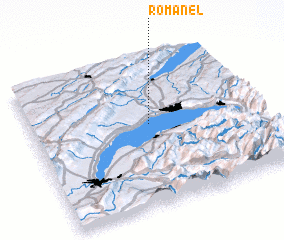 Places with similar names to Romanel, Switzerland ::
// Ramonal (BZ)
// Ramonal (BZ)
// Romanel (CH)
// Rummenohl (DE)
// Rumah Nalo (MY)
// Romanillo (CU)
// Ramonal (ES)
// Ramonal (MX)
// Raḩmānlū (IR)
// Río Manuel (GT)
Disclaimer :: Information on this page comes without warranty of any kind |
||
|
Where is Romanel? Elevation and coordinates ::
Latitude (lat): 46°33'0"N Longitude (lon): 6°31'0"E
Elevation (approx.): 474m (map arrows pan, magnifying glasses zoom) |
||
|
Visiting Romanel? Hotel/Accommodation ::
Book a hotel in Romanel Travel Guide ::
Buy a travel guide for Switzerland rental cars ::
car rental offers GPS waypoint ::
download a GPX waypoint (PoI) of Romanel for your GPS receiver
|
||