|
search place name
|
||
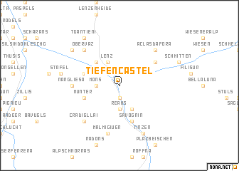
Tiefencastel (Aargau, Switzerland)Tiefencastel is a town in the Aargau region of Switzerland. An overview map of the region around Tiefencastel is displayed below.
regional and 3d topo map of Tiefencastel, Switzerland ::
Tiefencastel airports ::
The nearest airport is SMV - Samedan, located 26.4 km south east of Tiefencastel.
Other airports nearby include LUG - Lugano (88.5 km south west), ACH - St Gallen Altenrhein (92.8 km north), BGY - Bergamo Orio Al Serio (108.9 km south), FDH - Friedrichshafen (113.7 km north), Nearby towns ::
Salux (1.9km south) //
Brienz (2.2km north east) //
Reams (3.7km south) //
Mons (2.5km west) //
Lenz (3.9km north) //
Conters (3.9km south) //
Surava (3.1km north east) //
Alvaschein (4.5km north west) //
Savognin (5.7km south) //
Stürvis (4.2km north west) //
Munter (4.2km south west) //
Alvaneu (5.3km north east) //
Nargliesa (5.1km west) //
Malmigiuer (7.5km south) //
Cra digl Lai (6.7km south west) //
Obervaz (6.7km north west) //
Aclas Dafora (6.7km north east) //
Tinzen (7.8km south) //
Muldain (7.5km north west) //
Tgantieni (8.3km north west) //
Sporz (8.3km north west) //
[all distances 'as the bird flies' and approximate] 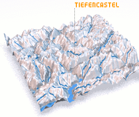 Places with similar names to Tiefencastel, Switzerland :: Disclaimer :: Information on this page comes without warranty of any kind |
||
|
Where is Tiefencastel? Elevation and coordinates ::
Latitude (lat): 46°39'0"N Longitude (lon): 9°35'0"E
Elevation (approx.): 1190m (map arrows pan, magnifying glasses zoom) |
||
|
Visiting Tiefencastel? Hotel/Accommodation ::
Book a hotel in Tiefencastel Travel Guide ::
Buy a travel guide for Switzerland rental cars ::
car rental offers GPS waypoint ::
download a GPX waypoint (PoI) of Tiefencastel for your GPS receiver
|
||