|
search place name
|
||
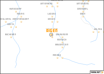
Aigen (Salzburg, Austria)Aigen is a town in the Salzburg region of Austria. An overview map of the region around Aigen is displayed below.
regional and 3d topo map of Aigen, Austria ::
Aigen airports ::
The nearest airport is SZG - Salzburg, located 71.9 km north of Aigen.
Other airports nearby include KLU - Klagenfurt (Worthersee Intl) (109.9 km south east), AVB - Aviano Ab (Pagliano E Gori) (130.1 km south), INN - Innsbruck (133.6 km west), LNZ - Linz (Horsching) (145.5 km north east), Nearby towns ::
Lafen (0.0km north) //
Hundsdorf (1.9km north) //
Bad Hofgastein (1.9km north) //
Heissingfelding (2.2km north east) //
Gadaunern (2.5km east) //
Kötschachdorf (3.1km south east) //
Remsach (3.1km south east) //
Badbruck (3.1km south east) //
Badgastein (4.5km south east) //
Wieden (5.6km north) //
Stein (5.6km north) //
Laderding (5.7km north) //
Luggau (7.4km north) //
Harbach (7.4km north) //
Passau (7.5km south) //
Böckstein (7.5km south) //
Anlauftal (7.8km south) //
[all distances 'as the bird flies' and approximate] 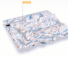 Places with similar names to Aigen, Austria ::
Disclaimer :: Information on this page comes without warranty of any kind |
||
|
Where is Aigen? Elevation and coordinates ::
Latitude (lat): 47°9'0"N Longitude (lon): 13°6'0"E
Elevation (approx.): 992m (map arrows pan, magnifying glasses zoom) |
||
|
Visiting Aigen? Hotel/Accommodation ::
Book a hotel in Aigen Travel Guide ::
Buy a travel guide for Austria rental cars ::
car rental offers GPS waypoint ::
download a GPX waypoint (PoI) of Aigen for your GPS receiver
|
||