|
search place name
|
||
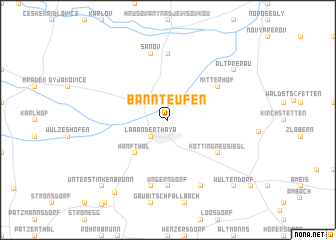
Bannteufen (Niederösterreich, Austria)Bannteufen is a town in the Niederösterreich region of Austria. An overview map of the region around Bannteufen is displayed below.
regional and 3d topo map of Bannteufen, Austria ::
Bannteufen airports ::
The nearest airport is BRQ - Turany, located 51.2 km north east of Bannteufen.
Other airports nearby include VIE - Vienna Schwechat (70.4 km south), BTS - Bratislava M R Stefanik (86.8 km south east), PZY - Piestany (105.9 km east), PRV - Prerov (106.4 km north east), Nearby towns ::
Laa an der Thaya (2.2km south west) //
Hevlín (2.2km north west) //
Hanfthal (4.4km south west) //
Kottingneusiedl (5.2km south east) //
Mitterhof (5.2km north east) //
Ungerndorf (7.4km south) //
Hrabětice (7.4km north) //
Altenmarkt (7.5km south) //
Kleinbaumgarten (7.5km south) //
Šanov (7.5km north) //
Hagendorf (7.8km south) //
Alt-Prerau (7.4km north east) //
Lehmgrube (9.0km south west) //
Unterstinkenbrunn (8.9km south west) //
Wultendorf (8.9km south east) //
[all distances 'as the bird flies' and approximate]  Places with similar names to Bannteufen, Austria ::
// Ban Na Ta Phan (TH)
// Bandevān (IR)
// Bandīvān (IR)
// Ban Taophan (LA)
// Ban Taphan (LA)
// Ban Taphan (LA)
// Ban Tavèn (LA)
// Ban Taveun (LA)
// Bandivan (AM)
Disclaimer :: Information on this page comes without warranty of any kind |
||
|
Where is Bannteufen? Elevation and coordinates ::
Latitude (lat): 48°44'0"N Longitude (lon): 16°24'0"E
Elevation (approx.): 185m (map arrows pan, magnifying glasses zoom) |
||
|
Visiting Bannteufen? Hotel/Accommodation ::
Book a hotel in Bannteufen Travel Guide ::
Buy a travel guide for Austria rental cars ::
car rental offers GPS waypoint ::
download a GPX waypoint (PoI) of Bannteufen for your GPS receiver
|
||