|
search place name
|
||
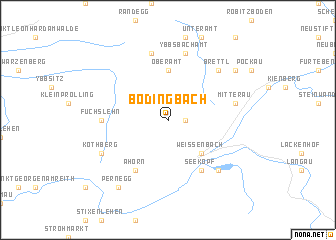
Bodingbach (Niederösterreich, Austria)Bodingbach is a town in the Niederösterreich region of Austria. An overview map of the region around Bodingbach is displayed below.
regional and 3d topo map of Bodingbach, Austria ::
Bodingbach airports ::
The nearest airport is LNZ - Linz (Horsching), located 71.0 km north west of Bodingbach.
Other airports nearby include GRZ - Graz (106.4 km south), VIE - Vienna Schwechat (119.4 km east), KLU - Klagenfurt (Worthersee Intl) (148.5 km south), SZG - Salzburg (149.8 km west), Nearby towns ::
Pfaffenschlag (1.2km east) //
Weissenbach (4.5km south east) //
Oberamt (5.6km north) //
Seekopf (6.1km south east) //
Ahorn (6.1km south west) //
Fuchslehn (5.0km west) //
Ybbsbachamt (7.5km north) //
Schadneramt (7.5km north) //
Mitterau (5.3km east) //
Lunz am See (6.7km south east) //
Brettl (6.7km north east) //
Kothberg (6.2km south west) //
Pernegg (8.3km south west) //
Altenreith (7.5km north east) //
[all distances 'as the bird flies' and approximate] 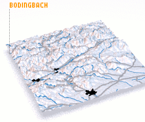 Places with similar names to Bodingbach, Austria :: Disclaimer :: Information on this page comes without warranty of any kind |
||
|
Where is Bodingbach? Elevation and coordinates ::
Latitude (lat): 47°54'0"N Longitude (lon): 15°0'0"E
Elevation (approx.): 810m (map arrows pan, magnifying glasses zoom) |
||
|
Visiting Bodingbach? Hotel/Accommodation ::
Book a hotel in Bodingbach Travel Guide ::
Buy a travel guide for Austria rental cars ::
car rental offers GPS waypoint ::
download a GPX waypoint (PoI) of Bodingbach for your GPS receiver
|
||