|
search place name
|
||
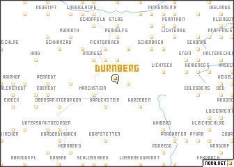
Dürnberg (Niederösterreich, Austria)Dürnberg is a town in the Niederösterreich region of Austria. An overview map of the region around Dürnberg is displayed below.
regional and 3d topo map of Dürnberg, Austria ::
Dürnberg airports ::
The nearest airport is LNZ - Linz (Horsching), located 61.9 km west of Dürnberg.
Other airports nearby include VIE - Vienna Schwechat (122.1 km east), BRQ - Turany (151.0 km north east), GRZ - Graz (160.4 km south), SZG - Salzburg (162.1 km south west), Nearby towns ::
Bärnkopf (1.2km east) //
Grosspertenschlag (3.7km north) //
Haruckstein (3.9km south) //
Kleinpertenschlag (3.9km north) //
Marchstein (3.1km south west) //
Kronegg (4.4km north west) //
Wurzeben (4.4km south east) //
Fichtenbach (5.7km north) //
Altmelon (5.7km north) //
Kleinsiegharts (5.7km north) //
Ottenschlag (4.9km west) //
Perwolfs (7.4km north) //
Lichteck (5.3km east) //
Dietrichsbach (6.7km north west) //
Schönbach (6.7km north east) //
Lengau (8.3km north east) //
Dorfstadt (7.4km north east) //
Purrath (8.9km north west) //
Wimberg (8.9km south east) //
[all distances 'as the bird flies' and approximate] 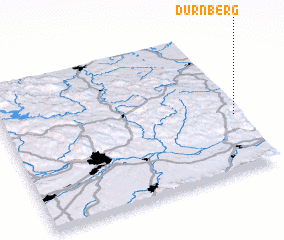 Places with similar names to Dürnberg, Austria ::
Disclaimer :: Information on this page comes without warranty of any kind |
||
|
Where is Dürnberg? Elevation and coordinates ::
Latitude (lat): 48°24'0"N Longitude (lon): 14°59'0"E
Elevation (approx.): 942m (map arrows pan, magnifying glasses zoom) |
||
|
Visiting Dürnberg? Hotel/Accommodation ::
Book a hotel in Dürnberg Travel Guide ::
Buy a travel guide for Austria rental cars ::
car rental offers GPS waypoint ::
download a GPX waypoint (PoI) of Dürnberg for your GPS receiver
|
||