|
search place name
|
||
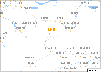
Fern (Oberösterreich, Austria)Fern is a town in the Oberösterreich region of Austria. An overview map of the region around Fern is displayed below.
regional and 3d topo map of Fern, Austria ::
Fern airports ::
The nearest airport is INN - Innsbruck, located 40.4 km east of Fern.
Other airports nearby include OBF - Oberpfaffenhofen (86.3 km north east), ACH - St Gallen Altenrhein (96.9 km west), FEL - Fuerstenfeldbruck Furstenfeldbruck (98.8 km north), FDH - Friedrichshafen (105.2 km west), Nearby towns ::
Fernstein (2.2km south west) //
Lähn (5.6km north) //
Nassereith (5.6km south) //
Wängle (5.7km north) //
Obergarten (5.7km north) //
Untergarten (5.7km north) //
Bichlbächle (5.3km north west) //
Stockach (5.3km north west) //
Lermoos (5.3km north east) //
Gries (6.1km north east) //
Biberwier (5.4km east) //
Bichlbach (6.7km north west) //
Aschland (6.7km south east) //
Holzleiten (6.7km south east) //
Dormitz (7.8km south) //
Weisland (7.5km south east) //
[all distances 'as the bird flies' and approximate] 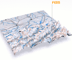 Places with similar names to Fern, Austria ::
Disclaimer :: Information on this page comes without warranty of any kind |
||
|
Where is Fern? Elevation and coordinates ::
Latitude (lat): 47°22'0"N Longitude (lon): 10°50'0"E
Elevation (approx.): 1364m (map arrows pan, magnifying glasses zoom) |
||
|
Visiting Fern? Hotel/Accommodation ::
Book a hotel in Fern Travel Guide ::
Buy a travel guide for Austria rental cars ::
car rental offers GPS waypoint ::
download a GPX waypoint (PoI) of Fern for your GPS receiver
|
||