|
search place name
|
||
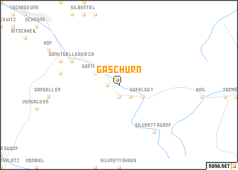
Gaschurn (Vorarlberg, Austria)Gaschurn is a town in the Vorarlberg region of Austria. An overview map of the region around Gaschurn is displayed below.
regional and 3d topo map of Gaschurn, Austria ::
Gaschurn airports ::
The nearest airport is SMV - Samedan, located 51.2 km south of Gaschurn.
Other airports nearby include ACH - St Gallen Altenrhein (66.3 km north west), FDH - Friedrichshafen (86.1 km north west), INN - Innsbruck (104.1 km east), BZO - Bolzano (114.7 km south east), Nearby towns ::
Bofen (1.9km south) //
Aussergosten (1.3km west) //
Innergosten (1.3km west) //
Pfanges (1.3km west) //
Rifen (1.9km south) //
Parthenen (2.2km south east) //
Gortipohl (3.1km north west) //
Gufelgut (3.1km south east) //
Sankt Gallenkirch (6.3km north west) //
Aussersiggam (6.3km north west) //
Silvrettadorf (8.3km south east) //
[all distances 'as the bird flies' and approximate] 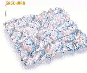 Places with similar names to Gaschurn, Austria ::
Disclaimer :: Information on this page comes without warranty of any kind |
||
|
Where is Gaschurn? Elevation and coordinates ::
Latitude (lat): 46°59'0"N Longitude (lon): 10°2'0"E
Elevation (approx.): 1044m (map arrows pan, magnifying glasses zoom) |
||
|
Visiting Gaschurn? Hotel/Accommodation ::
Book a hotel in Gaschurn Travel Guide ::
Buy a travel guide for Austria rental cars ::
car rental offers GPS waypoint ::
download a GPX waypoint (PoI) of Gaschurn for your GPS receiver
|
||