|
search place name
|
||
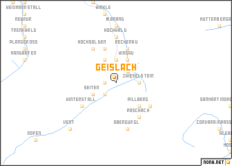
Geislach (Tirol, Austria)Geislach is a town in the Tirol region of Austria. An overview map of the region around Geislach is displayed below.
regional and 3d topo map of Geislach, Austria ::
Geislach airports ::
The nearest airport is INN - Innsbruck, located 44.7 km north east of Geislach.
Other airports nearby include BZO - Bolzano (58.2 km south east), SMV - Samedan (96.1 km south west), ACH - St Gallen Altenrhein (125.1 km north west), OBF - Oberpfaffenhofen (129.4 km north), Nearby towns ::
Neder (1.3km west) //
Puit (2.2km south west) //
Heiligenkreuz (2.2km south west) //
Kurzlehn (2.2km south west) //
Pitze (2.2km north east) //
Wohlfahrt (2.2km north east) //
Zwieselstein (2.5km east) //
Wald (3.7km north) //
Sölden (3.7km north) //
Seiten (3.1km south west) //
Rettenbach (3.9km north) //
Windau (3.9km north) //
Pillberg (4.5km south east) //
Kaisers (5.7km north) //
Rechenau (5.7km north) //
Haimbach (5.7km north) //
Hochsölden (6.1km north west) //
Winterstall (5.3km south west) //
Hochgurgl (5.3km south east) //
Poschach (6.1km south east) //
Pirchhütt (6.1km south east) //
Angern (6.1km south east) //
Hochwald (7.4km north) //
Obergurgl (7.5km south) //
Vent (9.0km south west) //
[all distances 'as the bird flies' and approximate] 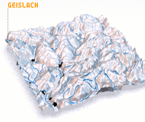 Places with similar names to Geislach, Austria :: Disclaimer :: Information on this page comes without warranty of any kind |
||
|
Where is Geislach? Elevation and coordinates ::
Latitude (lat): 46°56'0"N Longitude (lon): 11°0'0"E
Elevation (approx.): 1833m (map arrows pan, magnifying glasses zoom) |
||
|
Visiting Geislach? Hotel/Accommodation ::
Book a hotel in Geislach Travel Guide ::
Buy a travel guide for Austria rental cars ::
car rental offers GPS waypoint ::
download a GPX waypoint (PoI) of Geislach for your GPS receiver
|
||