|
search place name
|
||
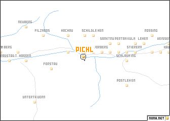
Pichl (Steiermark, Austria)Pichl is a town in the Steiermark region of Austria. An overview map of the region around Pichl is displayed below.
regional and 3d topo map of Pichl, Austria ::
nearby GPS traces from timatio ::
Pichl airports ::
The nearest airport is SZG - Salzburg, located 63.9 km north west of Pichl.
Other airports nearby include KLU - Klagenfurt (Worthersee Intl) (99.6 km south east), LNZ - Linz (Horsching) (104.2 km north east), LJU - Ljubliana Ljubljana (144.6 km south east), GRZ - Graz (146.1 km east), Nearby towns ::
Gleiming (1.9km north) //
Preunegg (2.2km north east) //
Mandling (3.1km north west) //
Vorberg (3.1km north east) //
Hierzegg (5.6km north) //
Rohrmoos (4.2km north east) //
Obere Klaus (4.2km north east) //
Salzburger Siedlung (4.2km north east) //
Schildlehen (5.7km north) //
Hachau (6.1km north west) //
Ramsau (5.3km north east) //
Forstau (5.4km west) //
Haslach (5.3km east) //
Sankt Rupert am Kulm (6.2km north east) //
Kulm (6.2km north east) //
[all distances 'as the bird flies' and approximate] 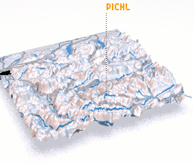 Places with similar names to Pichl, Austria ::
Disclaimer :: Information on this page comes without warranty of any kind |
||
|
Where is Pichl? Elevation and coordinates ::
Latitude (lat): 47°23'0"N Longitude (lon): 13°36'0"E
Elevation (approx.): 997m (map arrows pan, magnifying glasses zoom) |
||
|
Visiting Pichl? Hotel/Accommodation ::
Book a hotel in Pichl Travel Guide ::
Buy a travel guide for Austria rental cars ::
car rental offers GPS waypoint ::
download a GPX waypoint (PoI) of Pichl for your GPS receiver
|
||