|
search place name
|
||
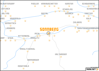
Sonnberg (Steiermark, Austria)Sonnberg is a town in the Steiermark region of Austria. An overview map of the region around Sonnberg is displayed below.
regional and 3d topo map of Sonnberg, Austria ::
Sonnberg airports ::
The nearest airport is KLU - Klagenfurt (Worthersee Intl), located 56.6 km south east of Sonnberg.
Other airports nearby include LJU - Ljubliana Ljubljana (102.7 km south), SZG - Salzburg (107.2 km north west), GRZ - Graz (112.4 km east), LNZ - Linz (Horsching) (128.9 km north), Nearby towns ::
Stadl an der Mur (0.0km north) //
Paal (1.9km south) //
Steindorf (1.3km east) //
Falkendorf (2.2km north east) //
Einach (2.5km west) //
Pichl (3.1km west) //
Predlitz (4.2km south west) //
Sankt Ruprecht ob Murau (4.2km north east) //
Seetal (7.5km north) //
Kaltwasser (8.5km south) //
Predlitzwinkel (8.3km south west) //
Seebach (9.0km north east) //
[all distances 'as the bird flies' and approximate] 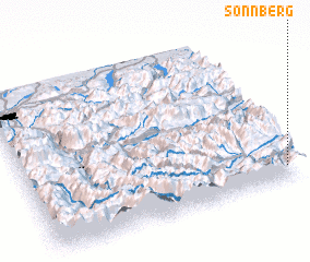 Places with similar names to Sonnberg, Austria ::
Disclaimer :: Information on this page comes without warranty of any kind |
||
|
Where is Sonnberg? Elevation and coordinates ::
Latitude (lat): 47°5'0"N Longitude (lon): 13°58'0"E
Elevation (approx.): 890m (map arrows pan, magnifying glasses zoom) |
||
|
Visiting Sonnberg? Hotel/Accommodation ::
Book a hotel in Sonnberg Travel Guide ::
Buy a travel guide for Austria rental cars ::
car rental offers GPS waypoint ::
download a GPX waypoint (PoI) of Sonnberg for your GPS receiver
|
||