|
search place name
|
||
Untergösing (Niederösterreich, Austria)Untergösing is a town in the Niederösterreich region of Austria. An overview map of the region around Untergösing is displayed below.
regional and 3d topo map of Untergösing, Austria ::

nearby GPS traces from timatio ::
Untergösing airports ::
The nearest airport is LNZ - Linz (Horsching), located 90.5 km north west of Untergösing.
Other airports nearby include VIE - Vienna Schwechat (99.3 km east), GRZ - Graz (99.9 km south), BTS - Bratislava M R Stefanik (147.4 km east), KLU - Klagenfurt (Worthersee Intl) (155.4 km south west), Nearby towns ::
Gösing an der Mariazeller Bahn (0.0km north) //
Obergösing (1.2km east) //
Brandeben (3.7km north) //
Puchenstuben (3.7km north) //
Wienerbruck (4.5km south east) //
Sulzbichl (4.5km north west) //
Brandgegend (4.5km north west) //
Lassingrotte (3.7km east) //
Hagen (5.7km south) //
Josefsrotte (6.1km south east) //
Josefsberg (6.1km south east) //
Mitterbach (7.5km south) //
Nestelberg (5.3km west) //
Winterbach (7.5km north) //
Seerotte (7.5km north east) //
[all distances 'as the bird flies' and approximate] 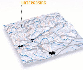 Places with similar names to Untergösing, Austria :: Disclaimer :: Information on this page comes without warranty of any kind |
||
|
Where is Untergösing? Elevation and coordinates ::
Latitude (lat): 47°53'0"N Longitude (lon): 15°17'0"E
Elevation (approx.): 724m (map arrows pan, magnifying glasses zoom) |
||
|
Visiting Untergösing? Hotel/Accommodation ::
Book a hotel in Untergösing Travel Guide ::
Buy a travel guide for Austria rental cars ::
car rental offers GPS waypoint ::
download a GPX waypoint (PoI) of Untergösing for your GPS receiver
|
||