|
search place name
|
||
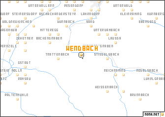
Wendbach (Oberösterreich, Austria)Wendbach is a town in the Oberösterreich region of Austria. An overview map of the region around Wendbach is displayed below.
regional and 3d topo map of Wendbach, Austria ::
Wendbach airports ::
The nearest airport is LNZ - Linz (Horsching), located 38.1 km north of Wendbach.
Other airports nearby include SZG - Salzburg (104.1 km west), GRZ - Graz (130.1 km south east), KLU - Klagenfurt (Worthersee Intl) (141.7 km south), MBX - Maribor (187.8 km south east), Nearby towns ::
Ternberg (3.1km north west) //
Wurmbachgraben (3.1km north east) //
Stiedelsbach (3.7km east) //
Losenstein (3.7km east) //
Trattenbach (3.7km west) //
Mühlbachgraben (6.1km north east) //
Oberdambach (7.5km north) //
Sand (7.5km north) //
Unterdambach (6.7km north east) //
Ebenboden (6.7km north west) //
Dürnbach (7.8km north) //
Bäckengraben (6.2km north west) //
Laussa (6.2km north east) //
Reichraming (6.2km south east) //
Mitteregg (7.5km north west) //
Losbichl (7.5km north east) //
Weissenbach (8.3km south east) //
[all distances 'as the bird flies' and approximate] 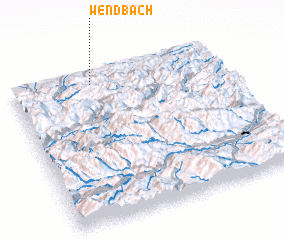 Places with similar names to Wendbach, Austria ::
// Windy Bush (US)
// Wendebach (DE)
Disclaimer :: Information on this page comes without warranty of any kind |
||
|
Where is Wendbach? Elevation and coordinates ::
Latitude (lat): 47°55'0"N Longitude (lon): 14°23'0"E
Elevation (approx.): 741m (map arrows pan, magnifying glasses zoom) |
||
|
Visiting Wendbach? Hotel/Accommodation ::
Book a hotel in Wendbach Travel Guide ::
Buy a travel guide for Austria rental cars ::
car rental offers GPS waypoint ::
download a GPX waypoint (PoI) of Wendbach for your GPS receiver
|
||