|
search place name
|
||
Winkl Reichenau (Kärnten, Austria)Winkl Reichenau is a town in the Kärnten region of Austria. An overview map of the region around Winkl Reichenau is displayed below.
regional and 3d topo map of Winkl Reichenau, Austria ::

Winkl Reichenau airports ::
The nearest airport is KLU - Klagenfurt (Worthersee Intl), located 45.1 km south east of Winkl Reichenau.
Other airports nearby include LJU - Ljubliana Ljubljana (86.4 km south east), SZG - Salzburg (120.2 km north west), GRZ - Graz (120.5 km east), TRS - Ronchi De Legionari Ronchi Dei Legionari (121.3 km south), Nearby towns ::
Saureggen (2.5km east) //
Hinterkoflach (3.8km south) //
Seebach (4.9km south) //
Schuß (4.7km south east) //
Vorwald (5.9km south) //
Lorenzenberg (4.9km south east) //
Vorderkoflach (6.1km south west) //
Ebene Reichenau (5.5km south east) //
Wiedweg (7.3km south) //
Rottenstein (7.4km south) //
Pattergassen (7.6km south) //
Sankt Lorenzen (6.0km south east) //
Turrach (8.7km north) //
Sankt Margarethen (8.7km south) //
Zirkitzen (8.8km south west) //
Kleinkirchheim (8.7km south west) //
Görzwinkl (9.2km south east) //
Bach (10.0km south west) //
[all distances 'as the bird flies' and approximate] 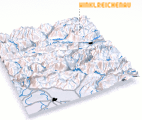 Places with similar names to Winkl Reichenau, Austria :: Disclaimer :: Information on this page comes without warranty of any kind |
||
|
Where is Winkl Reichenau? Elevation and coordinates ::
Latitude (lat): 46°53'3"N Longitude (lon): 13°51'51"E
Elevation (approx.): 1606m (map arrows pan, magnifying glasses zoom) |
||
|
Visiting Winkl Reichenau? Hotel/Accommodation ::
Book a hotel in Winkl Reichenau Travel Guide ::
Buy a travel guide for Austria rental cars ::
car rental offers GPS waypoint ::
download a GPX waypoint (PoI) of Winkl Reichenau for your GPS receiver
|
||