|
search place name
|
||
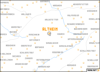
Altheim (Baden-Württemberg, Germany)Altheim is a town in the Baden-Württemberg region of Germany. An overview map of the region around Altheim is displayed below.
regional and 3d topo map of Altheim, Germany ::
Altheim airports ::
The nearest airport is GHF - Giebelstadt Aaf, located 40.3 km east of Altheim.
Other airports nearby include MHG - Mannheim City (67.6 km west), ZQC - Speyer (76.1 km west), ZNF - Hanau Aaf (80.1 km north west), FRA - Frankfurt Main (86.0 km north west), Nearby towns ::
Sindolsheim (3.8km south) //
Kudach (2.8km east) //
Dörntal (2.8km east) //
Waldstetten (5.0km north) //
Rinschheim (3.8km west) //
Götzingen (4.5km south west) //
Bofsheim (5.8km south west) //
Gerichtstetten (4.7km east) //
Erfeld (5.4km north east) //
Rosenberg (7.4km south) //
Hirschlanden (6.3km south east) //
Bretzingen (7.3km north east) //
Hettingen (5.5km west) //
Hohenstadt (6.2km south east) //
Bronnacker (8.9km south) //
Eberstadt (7.3km south west) //
Pülfringen (8.7km north east) //
Walldürn (9.0km north west) //
Schlierstadt (9.2km south west) //
[all distances 'as the bird flies' and approximate] 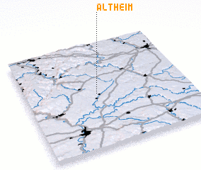 Places with similar names to Altheim, Germany ::
Disclaimer :: Information on this page comes without warranty of any kind |
||
|
Where is Altheim? Elevation and coordinates ::
Latitude (lat): 49°31'13"N Longitude (lon): 9°26'42"E
Elevation (approx.): 318m (map arrows pan, magnifying glasses zoom) |
||
|
Visiting Altheim? Hotel/Accommodation ::
Book a hotel in Altheim Travel Guide ::
Buy a travel guide for Germany rental cars ::
car rental offers GPS waypoint ::
download a GPX waypoint (PoI) of Altheim for your GPS receiver
|
||