|
search place name
|
||
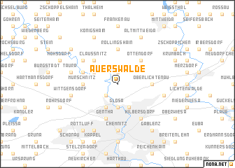
Auerswalde (Sachsen, Germany)Auerswalde is a town in the Sachsen region of Germany. An overview map of the region around Auerswalde is displayed below.
regional and 3d topo map of Auerswalde, Germany ::
Auerswalde airports ::
The nearest airport is AOC - Altenburg Nobitz, located 30.2 km west of Auerswalde.
Other airports nearby include DRS - Dresden (65.1 km north east), LEJ - Leipzig Halle (75.8 km north west), KLV - Karlovy Vary (77.5 km south), HOQ - Hof Plauen (101.4 km south west), Nearby towns ::
Garnsdorf (1.9km north) //
Draisdorf (2.2km south west) //
Heinersdorf (2.2km south west) //
Glösa (3.7km south) //
Furth (3.9km south) //
Borna (3.9km south) //
Köthensdorf-Reitzenhain (3.0km north west) //
Ottendorf (4.4km north east) //
Meusegast (4.4km north west) //
Claußnitz (4.4km north west) //
Oberlichtenau (3.5km east) //
Murschnitz (3.5km west) //
Röllingshain (5.6km north) //
Gentha (5.7km south) //
Markersdorf (4.0km north west) //
Hilbersdorf (6.0km south east) //
Schweizerthal (5.1km north west) //
Chemnitz (7.4km south) //
Ebersdorf (5.0km east) //
Taura (5.0km west) //
Wittgensdorf (5.0km west) //
Altmittweida (7.8km north) //
Königshain (7.8km north) //
Altendorf (7.8km south) //
Gablenz (8.2km south east) //
Rottluff (8.2km south west) //
Diethensdorf (7.3km north west) //
[all distances 'as the bird flies' and approximate]  Places with similar names to Auerswalde, Germany :: Disclaimer :: Information on this page comes without warranty of any kind |
||
|
Where is Auerswalde? Elevation and coordinates ::
Latitude (lat): 50°54'0"N Longitude (lon): 12°55'0"E
Elevation (approx.): 291m (map arrows pan, magnifying glasses zoom) |
||
|
Visiting Auerswalde? Hotel/Accommodation ::
Book a hotel in Auerswalde Travel Guide ::
Buy a travel guide for Germany rental cars ::
car rental offers GPS waypoint ::
download a GPX waypoint (PoI) of Auerswalde for your GPS receiver
|
||