|
search place name
|
||
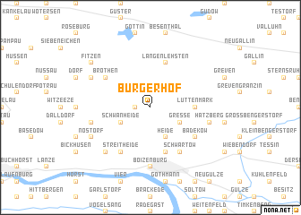
Bürgerhof (Mecklenburg-Vorpommern, Germany)Bürgerhof is a town in the Mecklenburg-Vorpommern region of Germany. An overview map of the region around Bürgerhof is displayed below.
regional and 3d topo map of Bürgerhof, Germany ::
Bürgerhof airports ::
The nearest airport is LBC - Luebeck Lubeck Blankensee, located 39.6 km north of Bürgerhof.
Other airports nearby include HAM - Hamburg (52.3 km north west), XFW - Hamburg Finkenwerder (59.2 km west), SZW - Schwerin Parchim (70.9 km east), ZCN - Celle (106.3 km south west), Nearby towns ::
Wendisch Lieps (1.9km north) //
Piperkaten (1.1km west) //
Heide (3.9km south) //
Leisterförde (2.9km north east) //
Gresse (2.9km south east) //
Schwanheide (2.9km south west) //
Lüttenmark (3.3km east) //
Langenlehsten (5.7km north) //
Metlitzhof (5.7km south) //
Bröthen (5.0km north west) //
Badekow (5.0km south east) //
Schwartow (6.0km south) //
Streitheide (6.0km south) //
Boizenburg (7.4km south) //
Hatzberg (4.8km south east) //
Heidekrug (4.8km south west) //
Gehrum (6.5km south west) //
Rensdorf (6.5km south west) //
Büchen (5.8km north west) //
Nostorf (5.8km south west) //
Fitzen (7.1km north west) //
[all distances 'as the bird flies' and approximate] 
Disclaimer :: Information on this page comes without warranty of any kind |
||
|
Where is Bürgerhof? Elevation and coordinates ::
Latitude (lat): 53°27'0"N Longitude (lon): 10°43'0"E
Elevation (approx.): 33m (map arrows pan, magnifying glasses zoom) |
||
|
Visiting Bürgerhof? Hotel/Accommodation ::
Book a hotel in Bürgerhof Travel Guide ::
Buy a travel guide for Germany rental cars ::
car rental offers GPS waypoint ::
download a GPX waypoint (PoI) of Bürgerhof for your GPS receiver
|
||