|
search place name
|
||
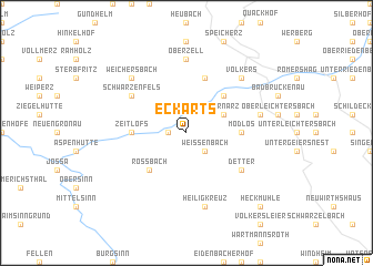
Eckarts (Bayern, Germany)Eckarts is a town in the Bayern region of Germany. An overview map of the region around Eckarts is displayed below.
regional and 3d topo map of Eckarts, Germany ::
Eckarts airports ::
The nearest airport is ZNF - Hanau Aaf, located 55.0 km west of Eckarts.
Other airports nearby include GHF - Giebelstadt Aaf (71.1 km south), FRA - Frankfurt Main (88.0 km west), ERF - Erfurt (118.4 km north east), MHG - Mannheim City (123.6 km south west), Nearby towns ::
Rupboden (1.2km west) //
Weißenbach (2.2km south east) //
Wernarz (3.0km north east) //
Staatsbad Brückenau (4.4km north east) //
Roßbach (4.4km south west) //
Zeitlofs (3.6km west) //
Modlos (3.6km east) //
Züntersbach (5.7km north) //
Güntershof (5.1km north west) //
Mottgers (5.1km north west) //
Schwarzenfels (5.1km north west) //
Detter (5.1km south east) //
Oberzell (7.4km north) //
Dreistelzhof (5.1km east) //
Heiligkreuz (7.5km south) //
Geisberg (6.6km north west) //
Neuenmühle (6.6km north west) //
Weichersbach (6.6km north west) //
Volkers (6.6km north east) //
Heckmühle (8.8km south east) //
[all distances 'as the bird flies' and approximate] 
Disclaimer :: Information on this page comes without warranty of any kind |
||
|
Where is Eckarts? Elevation and coordinates ::
Latitude (lat): 50°16'0"N Longitude (lon): 9°43'0"E
Elevation (approx.): 328m (map arrows pan, magnifying glasses zoom) |
||
|
Visiting Eckarts? Hotel/Accommodation ::
Book a hotel in Eckarts Travel Guide ::
Buy a travel guide for Germany rental cars ::
car rental offers GPS waypoint ::
download a GPX waypoint (PoI) of Eckarts for your GPS receiver
|
||