|
search place name
|
||
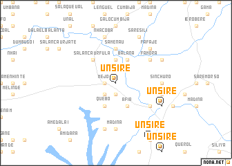
Unsirè (Guinea-Bissau)Unsirè is a town in Guinea-Bissau. An overview map of the region around Unsirè is displayed below.
regional and 3d topo map of Unsirè, Guinea-Bissau ::
Unsirè airports ::
The nearest airport is BXO - Bissau Oswaldo Vieira Intl, located 99.4 km north west of Unsirè.
Other airports nearby include FIG - Fira Fria (185.3 km south east), ZIG - Ziguinchor (198.5 km north west), CSK - Cap Skiring (230.3 km north west), BJL - Banjul Intl (288.4 km north west), Nearby towns ::
Mejo (1.8km west) //
Mereburum (1.9km south) //
Bananare (2.6km south west) //
Bamba Conholi (2.6km south west) //
Cabo Verde (3.7km north) //
Balana (4.1km north east) //
Quebo (4.1km south west) //
Áfià (4.1km south east) //
Salancaur Fula (5.2km north west) //
Samenau (5.6km north) //
Famora (6.6km north east) //
Guileje (6.6km south east) //
Madina (7.4km south) //
Sinchuro (7.3km east) //
Nhacobà (7.6km north) //
Gadabajá (7.6km south) //
Uali Sachà (7.5km east) //
Fafaje (7.8km north east) //
Sare Sili (8.3km north east) //
Bancobunje (8.2km north east) //
Unsirè (8.2km south east) //
[all distances 'as the bird flies' and approximate]  Places with similar names to Unsirè, Guinea-Bissau ::
Disclaimer :: Information on this page comes without warranty of any kind |
||
|
Where is Unsirè? Elevation and coordinates ::
Latitude (lat): 11°22'0"N Longitude (lon): 14°55'0"W
Elevation (approx.): 23m (map arrows pan, magnifying glasses zoom) |
||
|
Visiting Unsirè? Hotel/Accommodation ::
Book a hotel in Unsirè Travel Guide ::
rental cars ::
car rental offers GPS waypoint ::
download a GPX waypoint (PoI) of Unsirè for your GPS receiver
|
||