|
search place name
|
||
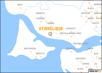
Utia Melique (Guinea-Bissau)Utia Melique is a town in Guinea-Bissau. An overview map of the region around Utia Melique is displayed below.
regional and 3d topo map of Utia Melique, Guinea-Bissau ::
Utia Melique airports ::
The nearest airport is BXO - Bissau Oswaldo Vieira Intl, located 59.6 km east of Utia Melique.
Other airports nearby include ZIG - Ziguinchor (71.2 km north), CSK - Cap Skiring (80.7 km north west), BJL - Banjul Intl (164.7 km north), Nearby towns ::
Binhangai (1.9km north) //
Pepal (1.9km north) //
Caió (1.9km north) //
Tebebe (3.7km north) //
Belabate (5.6km north) //
Bissói (5.8km north) //
Decântem (6.6km north west) //
Temanbu (6.6km north west) //
Ponta Leandro Lopes (7.3km east) //
Cajegute (7.5km east) //
Caiomete (8.3km north west) //
Quecete (8.3km south west) //
Cassaca (9.1km south east) //
Porto Parul (9.1km south west) //
Pijate (9.2km south west) //
Bagongo (9.2km south west) //
[all distances 'as the bird flies' and approximate] 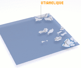 Places with similar names to Utia Melique, Guinea-Bissau ::
// Uchumullaca (PE)
Disclaimer :: Information on this page comes without warranty of any kind |
||
|
Where is Utia Melique? Elevation and coordinates ::
Latitude (lat): 11°55'0"N Longitude (lon): 16°12'0"W
Elevation (approx.): 5m (map arrows pan, magnifying glasses zoom) |
||
|
Visiting Utia Melique? Hotel/Accommodation ::
Book a hotel in Utia Melique Travel Guide ::
rental cars ::
car rental offers GPS waypoint ::
download a GPX waypoint (PoI) of Utia Melique for your GPS receiver
|
||