|
search place name
|
||
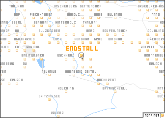
Endstall (Bayern, Germany)Endstall is a town in the Bayern region of Germany. An overview map of the region around Endstall is displayed below.
regional and 3d topo map of Endstall, Germany ::
Endstall airports ::
The nearest airport is OBF - Oberpfaffenhofen, located 63.1 km north west of Endstall.
Other airports nearby include INN - Innsbruck (69.7 km south west), MUC - Munich Munchen (70.1 km north), FEL - Fuerstenfeldbruck Furstenfeldbruck (73.2 km north west), SZG - Salzburg (79.3 km east), Nearby towns ::
Buchberg (0.0km north) //
Lehen (0.0km north) //
Point (1.9km south) //
Fischbachau (1.9km south) //
Bichl (1.9km south) //
Marbach (1.9km south) //
Mühlkreit (1.2km west) //
Durham (1.2km east) //
Ried (1.2km west) //
Steingraben (1.9km north) //
Elbach (1.9km north) //
Dürnbach (1.9km north) //
Greisbach (1.9km north) //
Faistenau (2.2km south west) //
Birkenstein (2.2km south east) //
Stauden (2.2km south west) //
Trach (2.2km south west) //
Sandbichl (2.2km south west) //
Ahrain (2.2km north west) //
Achau (2.2km north west) //
Hauserbichl (2.2km north west) //
Neumaier (2.2km north west) //
Riedler (3.7km south) //
Gschwend (2.5km west) //
Schwarzenberg (3.7km north) //
Hundham (3.7km north) //
Aurach (3.9km south) //
Mühlau (3.9km south) //
Kloo (3.9km south) //
[all distances 'as the bird flies' and approximate]  Places with similar names to Endstall, Germany :: Disclaimer :: Information on this page comes without warranty of any kind |
||
|
Where is Endstall? Elevation and coordinates ::
Latitude (lat): 47°44'0"N Longitude (lon): 11°57'0"E
Elevation (approx.): 781m (map arrows pan, magnifying glasses zoom) |
||
|
Visiting Endstall? Hotel/Accommodation ::
Book a hotel in Endstall Travel Guide ::
Buy a travel guide for Germany rental cars ::
car rental offers GPS waypoint ::
download a GPX waypoint (PoI) of Endstall for your GPS receiver
|
||