|
search place name
|
||
Gerstland (Bayern, Germany)Gerstland is a town in the Bayern region of Germany. An overview map of the region around Gerstland is displayed below.
regional and 3d topo map of Gerstland, Germany ::

Gerstland airports ::
The nearest airport is ACH - St Gallen Altenrhein, located 37.8 km west of Gerstland.
Other airports nearby include FDH - Friedrichshafen (40.0 km west), INN - Innsbruck (105.8 km east), OBF - Oberpfaffenhofen (107.8 km north east), ZRH - Zurich (112.8 km west), Nearby towns ::
Harbatshofen (1.2km west) //
Jungensberg (1.2km west) //
Oberthalhofen (1.2km west) //
Unterthalhofen (1.2km west) //
Schwanden (1.9km south) //
Ebratshofen (1.9km north) //
Mutten (1.9km south) //
Motzgatzried (1.9km north) //
Wolfsried (2.2km south west) //
Laubenberg (2.2km north west) //
Grünenbach (2.2km north west) //
Trabers (2.2km south east) //
Pfarrenberg (2.2km north east) //
Schüttentobel (2.2km north east) //
Riedholz (3.7km north) //
Holzleute (2.5km west) //
Stiefenhofen (2.5km west) //
Kalzhofen (3.7km south) //
Geratsried (2.5km east) //
Zell (3.9km south) //
Pfalzen (3.9km south) //
Sinswang (3.9km south) //
Buflings (3.9km south) //
Hohenegg (3.9km north) //
Hahnschenkel (3.1km south west) //
Ranzenried (3.1km south west) //
Schönau (3.1km north west) //
Lautenberg (3.1km south west) //
Tronsberg (3.9km south) //
[all distances 'as the bird flies' and approximate] 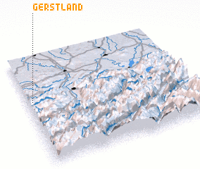 Places with similar names to Gerstland, Germany :: Disclaimer :: Information on this page comes without warranty of any kind |
||
|
Where is Gerstland? Elevation and coordinates ::
Latitude (lat): 47°36'0"N Longitude (lon): 10°2'0"E
Elevation (approx.): 932m (map arrows pan, magnifying glasses zoom) |
||
|
Visiting Gerstland? Hotel/Accommodation ::
Book a hotel in Gerstland Travel Guide ::
Buy a travel guide for Germany rental cars ::
car rental offers GPS waypoint ::
download a GPX waypoint (PoI) of Gerstland for your GPS receiver
|
||