|
search place name
|
||
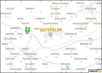
Gütersloh (Nordrhein-Westfalen, Germany)Gütersloh is a town in the Nordrhein-Westfalen region of Germany. An overview map of the region around Gütersloh is displayed below.
regional and 3d topo map of Gütersloh, Germany ::
Gütersloh airports ::
The nearest airport is GUT - Guetersloh Gutersloh, located 5.9 km north west of Gütersloh.
Other airports nearby include PAD - Paderborn Lippstadt (35.6 km south east), FMO - Muenster/osnabrueck Munster Osnabruck (54.6 km north west), ZCA - Arnsberg Menden (57.2 km south west), DTM - Dortmund (68.1 km south west), Nearby towns ::
Kattenstroth (2.2km south west) //
Nordhorn (2.2km north east) //
Blankenhagen (3.7km north) //
Sundern (2.3km east) //
Pavenstädt (2.9km north west) //
Niehorst (6.0km north) //
Isselhorst (6.0km north) //
Ems (4.6km west) //
Hollen (7.4km north) //
Sürenheide (4.6km east) //
An der Kapelle (7.5km south) //
Druffel (7.5km south) //
Holtkamp (7.5km north) //
Varensell (7.2km south east) //
Wiedenbrück (8.7km south west) //
Rheda-Wiedenbrück (8.7km south west) //
Ummeln (8.7km north east) //
Neuenkirchen (8.7km south east) //
[all distances 'as the bird flies' and approximate] 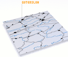 Places with similar names to Gütersloh, Germany :: Disclaimer :: Information on this page comes without warranty of any kind |
||
|
Where is Gütersloh? Elevation and coordinates ::
Latitude (lat): 51°54'0"N Longitude (lon): 8°23'0"E
Elevation (approx.): 76m (map arrows pan, magnifying glasses zoom) |
||
|
Visiting Gütersloh? Hotel/Accommodation ::
Book a hotel in Gütersloh Travel Guide ::
Buy a travel guide for Germany rental cars ::
car rental offers GPS waypoint ::
download a GPX waypoint (PoI) of Gütersloh for your GPS receiver
|
||