|
search place name
|
||
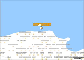
Hafthagen (Mecklenburg-Vorpommern, Germany)Hafthagen is a town in the Mecklenburg-Vorpommern region of Germany. An overview map of the region around Hafthagen is displayed below.
regional and 3d topo map of Hafthagen, Germany ::
Hafthagen airports ::
The nearest airport is LBC - Luebeck Lubeck Blankensee, located 36.8 km south west of Hafthagen.
Other airports nearby include RLG - Laage (74.9 km east), KEL - Kiel Holtenau (77.0 km north west), SZW - Schwerin Parchim (77.8 km south east), HAM - Hamburg (87.8 km south west), Nearby towns ::
Steinbeck (1.9km south) //
Elmenhorst (2.9km south west) //
Grundshagen (3.9km south) //
Wichmannsdorf (4.3km south east) //
Redewisch (4.3km south east) //
Klein Pravtshagen (4.3km south west) //
Arpshagen (5.6km south) //
Pölchow (3.8km south west) //
Niederklütz (5.7km south) //
Klütz (5.7km south) //
Hof zum Felde (7.5km south) //
Stellshagen (7.5km south) //
Warnkenhagen (4.7km south west) //
Christinenfeld (6.4km south east) //
Oberklütz (7.7km south) //
Goldbeck (7.7km south) //
Ostseebad Boltenhagen (5.7km south east) //
Hohen Schönberg (5.7km south west) //
Krummbrook (5.7km south west) //
Kühlenstein (8.1km south west) //
[all distances 'as the bird flies' and approximate]  Places with similar names to Hafthagen, Germany :: Disclaimer :: Information on this page comes without warranty of any kind |
||
|
Where is Hafthagen? Elevation and coordinates ::
Latitude (lat): 54°1'0"N Longitude (lon): 11°9'0"E
Elevation (approx.): -32768m (map arrows pan, magnifying glasses zoom) |
||
|
Visiting Hafthagen? Hotel/Accommodation ::
Book a hotel in Hafthagen Travel Guide ::
Buy a travel guide for Germany rental cars ::
car rental offers GPS waypoint ::
download a GPX waypoint (PoI) of Hafthagen for your GPS receiver
|
||