|
search place name
|
||
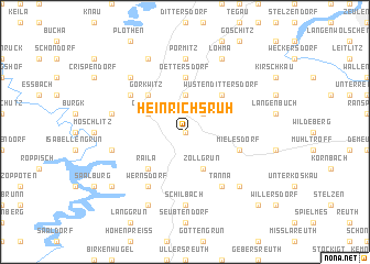
Heinrichsruh (Thüringen, Germany)Heinrichsruh is a town in the Thüringen region of Germany. An overview map of the region around Heinrichsruh is displayed below.
regional and 3d topo map of Heinrichsruh, Germany ::
Heinrichsruh airports ::
The nearest airport is HOQ - Hof Plauen, located 29.2 km south of Heinrichsruh.
Other airports nearby include BYU - Bayreuth (64.2 km south), AOC - Altenburg Nobitz (68.4 km north east), ERF - Erfurt (77.2 km north west), KLV - Karlovy Vary (87.1 km south east), Nearby towns ::
Oberoschitz (0.0km north) //
Oberböhmsdorf (2.2km north east) //
Schleiz (3.7km north) //
Zollgrün (3.9km south) //
Oschitz (3.0km north west) //
Wüstendittersdorf (4.4km north east) //
Raila (4.4km south west) //
Görkwitz (4.4km north west) //
Oettersdorf (5.6km north) //
Mielesdorf (4.0km south east) //
Tanna (6.0km south east) //
Mönchgrün (5.1km north west) //
Wernsdorf (6.0km south west) //
Schilbach (7.4km south) //
Pörmitz (7.4km north) //
Gräfenwarth (5.1km west) //
Grochwitz (5.1km west) //
Frankendorf (6.6km south east) //
Neundorf (6.6km north west) //
Löhma (7.8km north) //
Künsdorf (7.8km south) //
Pahnstangen (7.8km north) //
Kulm (7.3km south west) //
Ebersberg (8.8km south east) //
Löhla (8.8km south east) //
[all distances 'as the bird flies' and approximate]  Places with similar names to Heinrichsruh, Germany ::
// Heinrichsruh (DE)
// Heinrichsruh (DE)
Disclaimer :: Information on this page comes without warranty of any kind |
||
|
Where is Heinrichsruh? Elevation and coordinates ::
Latitude (lat): 50°33'0"N Longitude (lon): 11°49'0"E
Elevation (approx.): 532m (map arrows pan, magnifying glasses zoom) |
||
|
Visiting Heinrichsruh? Hotel/Accommodation ::
Book a hotel in Heinrichsruh Travel Guide ::
Buy a travel guide for Germany rental cars ::
car rental offers GPS waypoint ::
download a GPX waypoint (PoI) of Heinrichsruh for your GPS receiver
|
||