|
search place name
|
||
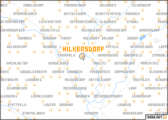
Hilkersdorf (Bayern, Germany)Hilkersdorf is a town in the Bayern region of Germany. An overview map of the region around Hilkersdorf is displayed below.
regional and 3d topo map of Hilkersdorf, Germany ::
Hilkersdorf airports ::
The nearest airport is BYU - Bayreuth, located 57.2 km east of Hilkersdorf.
Other airports nearby include NUE - Nuernberg Nurnberg (65.1 km south), HOQ - Hof Plauen (75.9 km east), GHF - Giebelstadt Aaf (78.8 km south west), ERF - Erfurt (101.9 km north), Nearby towns ::
Gleusdorf (1.9km north) //
Mürsbach (1.2km east) //
Kaltenherberg (2.2km north east) //
Busendorf (2.2km north east) //
Losbergsgereuth (2.2km north west) //
Zaugendorf (2.2km south east) //
Helfenroth (2.2km south east) //
Treinfeld (2.4km west) //
Speiersberg (2.4km east) //
Hemmendorf (3.7km north) //
Gräfenholz (3.0km south west) //
Medlitz (3.0km south east) //
Lahm (3.9km north) //
Pülsdorf (3.9km north) //
Untermanndorf (3.9km south) //
Laimbach (3.9km south) //
Obermanndorf (3.9km south) //
Fierst (4.4km north west) //
Freudeneck (4.4km south east) //
Lind (3.6km west) //
Rentweinsdorf (3.6km west) //
Birkach (3.6km east) //
Ummersberg (3.6km east) //
Ebern (4.0km north west) //
Messenfeld (4.0km north east) //
Höfen (5.7km south) //
Reckendorf (5.7km south) //
Sendelbach (4.0km south west) //
Recheldorf (5.7km north) //
[all distances 'as the bird flies' and approximate]  Places with similar names to Hilkersdorf, Germany :: Disclaimer :: Information on this page comes without warranty of any kind |
||
|
Where is Hilkersdorf? Elevation and coordinates ::
Latitude (lat): 50°4'0"N Longitude (lon): 10°51'0"E
Elevation (approx.): 310m (map arrows pan, magnifying glasses zoom) |
||
|
Visiting Hilkersdorf? Hotel/Accommodation ::
Book a hotel in Hilkersdorf Travel Guide ::
Buy a travel guide for Germany rental cars ::
car rental offers GPS waypoint ::
download a GPX waypoint (PoI) of Hilkersdorf for your GPS receiver
|
||