|
search place name
|
||
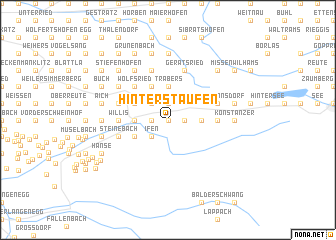
Hinterstaufen (Bayern, Germany)Hinterstaufen is a town in the Bayern region of Germany. An overview map of the region around Hinterstaufen is displayed below.
regional and 3d topo map of Hinterstaufen, Germany ::
Hinterstaufen airports ::
The nearest airport is ACH - St Gallen Altenrhein, located 37.5 km west of Hinterstaufen.
Other airports nearby include FDH - Friedrichshafen (42.7 km west), INN - Innsbruck (102.8 km east), OBF - Oberpfaffenhofen (109.6 km north east), ZRH - Zurich (113.5 km west), Nearby towns ::
Wengen (0.0km north) //
Oberstaufen (1.3km west) //
Salmas (1.3km east) //
Knechtenhofen (1.3km east) //
Weissach (1.3km west) //
Tronsberg (1.9km north) //
Buchenegg (2.2km south west) //
Ifen (2.2km south west) //
Kalzhofen (2.2km north west) //
Thalkirchdorf (2.5km east) //
Lamprechts (2.5km east) //
Malas (2.5km west) //
Stiesberg (2.5km west) //
Trabers (3.7km north) //
Höfen (3.1km south west) //
Steibis (3.1km south west) //
Zell (3.1km north west) //
Sinswang (3.1km north west) //
Buflings (3.1km north west) //
Pfalzen (3.1km north west) //
Schwanden (3.9km north) //
Mutten (3.9km north) //
Wolfsried (4.5km north west) //
Osterdorf (3.8km east) //
Willis (3.8km west) //
Berg (3.8km west) //
Steinebach (4.2km south west) //
Halden (4.2km south west) //
Schindelberg (4.2km south west) //
[all distances 'as the bird flies' and approximate]  Places with similar names to Hinterstaufen, Germany :: Disclaimer :: Information on this page comes without warranty of any kind |
||
|
Where is Hinterstaufen? Elevation and coordinates ::
Latitude (lat): 47°33'0"N Longitude (lon): 10°3'0"E
Elevation (approx.): 814m (map arrows pan, magnifying glasses zoom) |
||
|
Visiting Hinterstaufen? Hotel/Accommodation ::
Book a hotel in Hinterstaufen Travel Guide ::
Buy a travel guide for Germany rental cars ::
car rental offers GPS waypoint ::
download a GPX waypoint (PoI) of Hinterstaufen for your GPS receiver
|
||