|
search place name
|
||
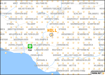
Höll (Baden-Württemberg, Germany)Höll is a town in the Baden-Württemberg region of Germany. An overview map of the region around Höll is displayed below.
regional and 3d topo map of Höll, Germany ::
Höll airports ::
The nearest airport is FDH - Friedrichshafen, located 6.3 km south west of Höll.
Other airports nearby include ACH - St Gallen Altenrhein (24.0 km south), ZRH - Zurich (82.1 km west), ZQL - Donaueschingen Villingen (85.0 km west), STR - Stuttgart (113.3 km north), Nearby towns ::
Obermeckenbeuren (0.0km north) //
Meckenbeuren (1.2km west) //
Schwarzenbach (1.9km north) //
Hirschach (1.2km east) //
Feurenmoos (1.2km east) //
Blumenrain (1.2km east) //
Bechlingen (1.9km south) //
Fünfehrlen (1.9km south) //
Moos (2.2km south west) //
Reute (2.2km south west) //
Hegenberg (2.2km north east) //
Langentrog (2.2km north east) //
Liebenau (2.2km north east) //
Ottmarsreute (2.2km north east) //
Dieglishofen (2.2km south east) //
Kaltenberg (2.2km south east) //
Lachen (3.7km north) //
Senglingen (3.7km north) //
Brochenzell (2.5km west) //
Brand (2.5km west) //
Knellesberg (2.5km east) //
Siggenweiler (2.5km east) //
Untertennenmoos (2.5km east) //
Unterpfingstweid (3.9km south) //
Untereschach (3.9km north) //
Eschach (3.9km north) //
Obereschach (3.9km north) //
Oberhofen (3.9km north) //
Brugg (3.1km north west) //
[all distances 'as the bird flies' and approximate]  Places with similar names to Höll, Germany ::
Disclaimer :: Information on this page comes without warranty of any kind |
||
|
Where is Höll? Elevation and coordinates ::
Latitude (lat): 47°42'0"N Longitude (lon): 9°35'0"E
Elevation (approx.): 437m (map arrows pan, magnifying glasses zoom) |
||
|
Visiting Höll? Hotel/Accommodation ::
Book a hotel in Höll Travel Guide ::
Buy a travel guide for Germany rental cars ::
car rental offers GPS waypoint ::
download a GPX waypoint (PoI) of Höll for your GPS receiver
|
||