|
search place name
|
||
Klein Krams (Mecklenburg-Vorpommern, Germany)Klein Krams is a town in the Mecklenburg-Vorpommern region of Germany. An overview map of the region around Klein Krams is displayed below.
regional and 3d topo map of Klein Krams, Germany ::

Klein Krams airports ::
The nearest airport is SZW - Schwerin Parchim, located 35.2 km north east of Klein Krams.
Other airports nearby include LBC - Luebeck Lubeck Blankensee (68.2 km north west), RLG - Laage (94.5 km north east), HAM - Hamburg (94.6 km north west), XFW - Hamburg Finkenwerder (100.7 km west), Nearby towns ::
Alt Krenzlin (1.9km north) //
Leussow (2.2km south west) //
Krenzliner Hütte (2.2km north east) //
Loosen (2.2km west) //
Menkendorf (3.9km south) //
Kavelmoor (4.3km south west) //
Groß Krams (4.3km north west) //
Bresegard (5.6km north) //
Grebs (5.7km south) //
Neu Krenzlin (3.8km north east) //
Göhlen (4.4km east) //
Neu Grebs (7.4km south) //
Bresegard (7.4km north) //
Glaisin (4.8km south east) //
Laupin (6.5km south west) //
Picher (6.5km north east) //
Conow (7.7km south) //
Niendorf (7.7km south) //
Bresegard (7.1km south east) //
Karenz (8.1km south east) //
[all distances 'as the bird flies' and approximate] 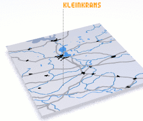 Places with similar names to Klein Krams, Germany :: Disclaimer :: Information on this page comes without warranty of any kind |
||
|
Where is Klein Krams? Elevation and coordinates ::
Latitude (lat): 53°18'0"N Longitude (lon): 11°18'0"E
Elevation (approx.): 49m (map arrows pan, magnifying glasses zoom) |
||
|
Visiting Klein Krams? Hotel/Accommodation ::
Book a hotel in Klein Krams Travel Guide ::
Buy a travel guide for Germany rental cars ::
car rental offers GPS waypoint ::
download a GPX waypoint (PoI) of Klein Krams for your GPS receiver
|
||