|
search place name
|
||
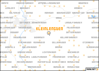
Klein Lengden (Niedersachsen, Germany)Klein Lengden is a town in the Niedersachsen region of Germany. An overview map of the region around Klein Lengden is displayed below.
regional and 3d topo map of Klein Lengden, Germany ::
Klein Lengden airports ::
The nearest airport is KSF - Kassel Calden, located 45.6 km west of Klein Lengden.
Other airports nearby include ERF - Erfurt (87.6 km south east), PAD - Paderborn Lippstadt (97.9 km west), BWE - Braunschweig Wolfsburg (98.4 km north), HAJ - Hannover (109.3 km north), Nearby towns ::
Groß Lengden (2.2km north east) //
Benniehausen (3.0km south east) //
Diemarden (3.0km south west) //
Gelliehausen (4.4km south east) //
Reinhausen (4.4km south west) //
Herberhausen (4.4km north west) //
Waake (6.0km north east) //
Bremke (6.0km south east) //
Mackenrode (5.1km north east) //
Lichtenhagen (7.4km south) //
Roringen (7.4km north) //
Potzwenden (5.0km east) //
Wöllmarshausen (5.0km east) //
Ischenrode (7.5km south) //
Geismar (5.0km west) //
Nikolausberg (7.8km north) //
Bischhausen (7.2km south east) //
Ballenhausen (7.2km south west) //
Bösinghausen (8.2km north east) //
Weende (8.7km north west) //
[all distances 'as the bird flies' and approximate]  Places with similar names to Klein Lengden, Germany :: Disclaimer :: Information on this page comes without warranty of any kind |
||
|
Where is Klein Lengden? Elevation and coordinates ::
Latitude (lat): 51°30'0"N Longitude (lon): 10°1'0"E
Elevation (approx.): 221m (map arrows pan, magnifying glasses zoom) |
||
|
Visiting Klein Lengden? Hotel/Accommodation ::
Book a hotel in Klein Lengden Travel Guide ::
Buy a travel guide for Germany rental cars ::
car rental offers GPS waypoint ::
download a GPX waypoint (PoI) of Klein Lengden for your GPS receiver
|
||