|
search place name
|
||
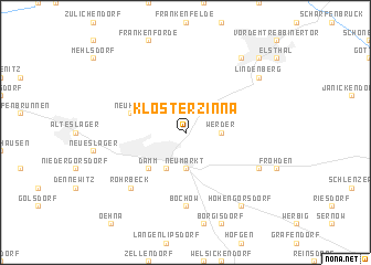
Kloster Zinna (Brandenburg, Germany)Kloster Zinna is a town in the Brandenburg region of Germany. An overview map of the region around Kloster Zinna is displayed below.
regional and 3d topo map of Kloster Zinna, Germany ::
Kloster Zinna airports ::
The nearest airport is SXF - Berlin Schonefeld, located 49.7 km north east of Kloster Zinna.
Other airports nearby include THF - Berlin Tempelhof (54.9 km north), TXL - Berlin Tegel (61.8 km north), LEJ - Leipzig Halle (88.0 km south west), DRS - Dresden (108.7 km south east), Nearby towns ::
Grüna (2.2km north west) //
Neue Häuser (2.2km north east) //
Kaltenhausen (2.2km north east) //
Werder (2.3km east) //
Neumarkt (3.7km south) //
Neuhof (2.9km north east) //
Jüterbog (3.9km south) //
Damm (4.4km south west) //
Neuheim (3.9km north west) //
Bochow (7.4km south) //
Rohrbeck (6.5km south west) //
Markendorf (5.9km south east) //
Weinberge (8.2km north east) //
Lindenberg (7.2km north east) //
Kolzenburg (7.2km north east) //
Hohengörsdorf (8.2km south east) //
Luckenwalde (8.7km north east) //
Vor dem Jüterborger Tor (8.7km north east) //
[all distances 'as the bird flies' and approximate]  Places with similar names to Kloster Zinna, Germany ::
// Klosterseeon (DE)
Disclaimer :: Information on this page comes without warranty of any kind |
||
|
Where is Kloster Zinna? Elevation and coordinates ::
Latitude (lat): 52°1'0"N Longitude (lon): 13°6'0"E
Elevation (approx.): 66m (map arrows pan, magnifying glasses zoom) |
||
|
Visiting Kloster Zinna? Hotel/Accommodation ::
Book a hotel in Kloster Zinna Travel Guide ::
Buy a travel guide for Germany rental cars ::
car rental offers GPS waypoint ::
download a GPX waypoint (PoI) of Kloster Zinna for your GPS receiver
|
||