|
search place name
|
||
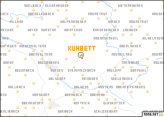
Kuhbett (Hessen, Germany)Kuhbett is a town in the Hessen region of Germany. An overview map of the region around Kuhbett is displayed below.
regional and 3d topo map of Kuhbett, Germany ::
Kuhbett airports ::
The nearest airport is FRA - Frankfurt Main, located 35.6 km south east of Kuhbett.
Other airports nearby include ZNF - Hanau Aaf (47.7 km east), ZNV - Koblenz Winningen (57.3 km west), HHN - Frankfurt Hahn (86.7 km south west), MHG - Mannheim City (94.8 km south), Nearby towns ::
Hasselbach (2.2km north east) //
Dombach (2.2km south west) //
Schwickershausen (2.4km west) //
Steinfischbach (3.7km south) //
Cratzenbach (4.0km north east) //
Haintchen (5.7km north) //
Reinborn (5.7km south) //
Rod an der Weil (5.1km north east) //
Würges (5.1km south west) //
Reichenbach (6.0km south east) //
Waldems (7.4km south) //
Wolfenhausen (7.5km north) //
Bad Camberg (5.1km west) //
Esch (7.5km south) //
Riedelbach (5.1km east) //
Walsdorf (6.6km south west) //
Emmershausen (6.6km north east) //
Mauloff (6.0km south east) //
Niederems (7.8km south) //
Langhecke (8.2km north west) //
Münster (7.3km north west) //
Wüstems (8.2km south east) //
Heinzenberg (8.8km north east) //
Winden (8.8km north east) //
[all distances 'as the bird flies' and approximate]  Places with similar names to Kuhbett, Germany ::
Disclaimer :: Information on this page comes without warranty of any kind |
||
|
Where is Kuhbett? Elevation and coordinates ::
Latitude (lat): 50°19'0"N Longitude (lon): 8°20'0"E
Elevation (approx.): 511m (map arrows pan, magnifying glasses zoom) |
||
|
Visiting Kuhbett? Hotel/Accommodation ::
Book a hotel in Kuhbett Travel Guide ::
Buy a travel guide for Germany rental cars ::
car rental offers GPS waypoint ::
download a GPX waypoint (PoI) of Kuhbett for your GPS receiver
|
||