|
search place name
|
||
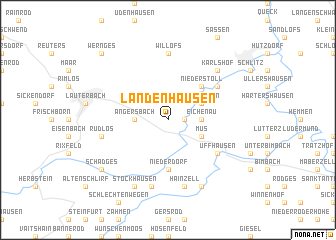
Landenhausen (Hessen, Germany)Landenhausen is a town in the Hessen region of Germany. An overview map of the region around Landenhausen is displayed below.
regional and 3d topo map of Landenhausen, Germany ::
Landenhausen airports ::
The nearest airport is ZNF - Hanau Aaf, located 62.1 km south west of Landenhausen.
Other airports nearby include KSF - Kassel Calden (88.4 km north), FRA - Frankfurt Main (93.8 km south west), ERF - Erfurt (111.5 km east), GHF - Giebelstadt Aaf (113.1 km south), Nearby towns ::
Bad Salzschlirf (1.2km east) //
Angersbach (2.4km west) //
Eichenau (2.4km east) //
Ützhausen (3.0km north east) //
Müs (3.0km south east) //
Nieder-Stoll (4.4km north east) //
Niederdorf (5.6km south) //
Bernshausen (5.1km north east) //
Uffhausen (5.1km south east) //
Großenlüder (5.1km south east) //
Willofs (7.4km north) //
Rudlos (5.1km west) //
Blankenau (7.5km south) //
Hainzell (7.5km south) //
Karlshof (6.6km north east) //
Stockhausen (7.8km south) //
Kleinlüder (7.8km south) //
Schadges (7.3km south west) //
Wernges (8.8km north west) //
[all distances 'as the bird flies' and approximate] 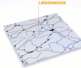 Places with similar names to Landenhausen, Germany :: Disclaimer :: Information on this page comes without warranty of any kind |
||
|
Where is Landenhausen? Elevation and coordinates ::
Latitude (lat): 50°37'0"N Longitude (lon): 9°29'0"E
Elevation (approx.): 277m (map arrows pan, magnifying glasses zoom) |
||
|
Visiting Landenhausen? Hotel/Accommodation ::
Book a hotel in Landenhausen Travel Guide ::
Buy a travel guide for Germany rental cars ::
car rental offers GPS waypoint ::
download a GPX waypoint (PoI) of Landenhausen for your GPS receiver
|
||