|
search place name
|
||
Latferde (Niedersachsen, Germany)Latferde is a town in the Niedersachsen region of Germany. An overview map of the region around Latferde is displayed below.
regional and 3d topo map of Latferde, Germany ::

Latferde airports ::
The nearest airport is HAJ - Hannover, located 50.6 km north of Latferde.
Other airports nearby include KSF - Kassel Calden (69.6 km south), PAD - Paderborn Lippstadt (73.1 km south west), ZCN - Celle (73.9 km north east), GUT - Guetersloh Gutersloh (78.4 km west), Nearby towns ::
Grohnde (2.2km south west) //
Frenke (2.2km south east) //
Börry (2.3km east) //
Hagenohsen (2.9km north west) //
Hajen (3.9km south) //
Völkerhausen (3.9km north) //
Voremberg (3.9km north) //
Brockensen (3.4km east) //
Hastenbeck (5.7km north) //
Emmern (3.9km north west) //
Kirchohsen (3.9km north west) //
Daspe (6.0km south) //
Bessinghausen (4.9km east) //
Hehlen (6.5km south east) //
Tündern (5.9km north west) //
Brökeln (7.8km south) //
Afferde (7.8km north) //
Diedersen (7.8km north) //
Behrensen (7.8km north) //
Lüntorf (7.2km south west) //
Bisperode (7.2km north east) //
Bessingen (8.7km north east) //
[all distances 'as the bird flies' and approximate] 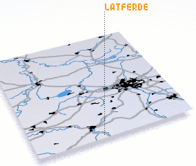 Places with similar names to Latferde, Germany ::
Disclaimer :: Information on this page comes without warranty of any kind |
||
|
Where is Latferde? Elevation and coordinates ::
Latitude (lat): 52°2'0"N Longitude (lon): 9°26'0"E
Elevation (approx.): 78m (map arrows pan, magnifying glasses zoom) |
||
|
Visiting Latferde? Hotel/Accommodation ::
Book a hotel in Latferde Travel Guide ::
Buy a travel guide for Germany rental cars ::
car rental offers GPS waypoint ::
download a GPX waypoint (PoI) of Latferde for your GPS receiver
|
||