|
search place name
|
||
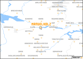
Mandelholz (Sachsen-Anhalt, Germany)Mandelholz is a town in the Sachsen-Anhalt region of Germany. An overview map of the region around Mandelholz is displayed below.
regional and 3d topo map of Mandelholz, Germany ::
Mandelholz airports ::
The nearest airport is BWE - Braunschweig Wolfsburg, located 66.1 km north of Mandelholz.
Other airports nearby include ERF - Erfurt (85.5 km south), KSF - Kassel Calden (99.6 km west), ZCN - Celle (106.6 km north west), HAJ - Hannover (107.5 km north west), Nearby towns ::
Neuehütte (2.2km north east) //
Tanne (3.7km south) //
Elend (2.3km west) //
Hohne (3.7km north) //
Scheunenhof (3.0km north east) //
Königshütte (3.0km north east) //
Voigtsfelde (4.4km south west) //
Königshof (3.4km east) //
Wietfeld (3.9km south west) //
Sorge (5.7km south) //
Rothehütte (3.9km north east) //
Schierke (5.1km north west) //
Benneckenstein (7.4km south) //
Kahlenberg (6.5km south east) //
Neu Vandsburg (5.9km north east) //
Hohegeiß (8.2km south west) //
Trautenstein (7.2km south east) //
Büchenberg (8.7km north east) //
[all distances 'as the bird flies' and approximate]  Places with similar names to Mandelholz, Germany :: Disclaimer :: Information on this page comes without warranty of any kind |
||
|
Where is Mandelholz? Elevation and coordinates ::
Latitude (lat): 51°44'0"N Longitude (lon): 10°43'0"E
Elevation (approx.): 511m (map arrows pan, magnifying glasses zoom) |
||
|
Visiting Mandelholz? Hotel/Accommodation ::
Book a hotel in Mandelholz Travel Guide ::
Buy a travel guide for Germany rental cars ::
car rental offers GPS waypoint ::
download a GPX waypoint (PoI) of Mandelholz for your GPS receiver
|
||